Rudna Mała geodata
Rudna Mała (Subcarpathian) is a populated place; located in Poland in Europe/Warsaw (GMT+2) time zone. With population of 1,023 people, there are 2426 cities with bigger population in this country. Compared to other cities in Poland, 78% of cities are located further ↑North; 84.3% of cities are located further ←West and 61.9% of cities have lower elevation than Rudna Mała. Note1
Administrative division(s):
- Level 1: Subcarpathian
- Level 2: Powiat rzeszowski
- Level 3: Głogów Małopolski


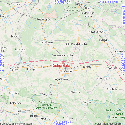
Rudna Mała GPS coordinates[2]
50° 5' 56.004" North, 21° 57' 36.756" East
| Map corner | latitude | longitude |
|---|---|---|
| Upper-left | 50.5478°, | 21.25709° |
| Center: | 50.09889°, | 21.96021° |
| Lower-right: | 49.64574°, | 22.66334° |
| Map W x H: | 100.3×100.3 km | = 62.3×62.3mi |
| max Lat: | 54.83135° ⇑78% North |
| Rudna Mała: | 50.09889° |
| min Lat: | ⇓22% South 49.21328° |
| min Long | Rudna Mała | max Long |
| 14.20249° | 21.96021° | 24.03723° |
| W 84.3%⇐ | ⇒15.7% E |
Elevation
Elevation of Rudna Mała is 205 m = 673 ft, and this is 13.6 m = 45 ft above average elevation for this country.
| Max E: |
974 m = 3196 ft | 38.1% |
| Rudna Mała | 205 m 673 ft | |
| Avg. | 191.4 m = 628 ft | |
Min E: |
-3 m = -10 ft | 61.9% |
See also: Poland elevation on elevation.city.
Geographical zone
Rudna Mała is located in North temperate zone (between Tropic of Cancer and the Arctic Circle). Distance of this North polar circle is 1830.7 km =1137.5 mi to North.| Distance of | km | miles | from Rudna Mała |
|---|---|---|---|
| North Pole | 4436.6 | 2756.8 | to North |
| Arctic Circle | 1830.7 | 1137.5 | to North |
| Tropic Cancer | 2964.6 | 1842.1 | to South |
| Equator | 5570.5 | 3461.3 | to South |


Nearby cities:
15 places around Rudna Mała: (largest is in red/bold)
• Boguchwała
12.7 km =7.9 mi,  184°
184°
• Głogów Małopolski
5.8 km =3.6 mi,  1°
1°
• Kielanówka
8.4 km =5.2 mi,  195°
195°
• Krasne
10.2 km =6.3 mi,  117°
117°
• Lutoryż
15 km =9.3 mi,  193°
193°
• Niechobrz
13 km =8.1 mi,  206°
206°
• Przybyszówka
6.2 km =3.9 mi, 203°
• Rudna Wielka
1.5 km =0.9 mi,  216°
216°
• Rzeszów
7 km =4.3 mi,  156°
156°
• Trzciana
9.2 km =5.7 mi,  250°
250°
• Trzebownisko
5.9 km =3.7 mi,  112°
112°
• Wysoka Głogowska
8.1 km =5 mi,  32°
32°
• Wólka Podleśna
11 km =6.8 mi,  78°
78°
• Zgłobień
12.2 km =7.6 mi, 218°
• Świlcza
5.4 km =3.4 mi,  235°
235°
Sources, notices
• [Note1] Compared only with cities in Poland existing in our database
• [Src1] Map data: © OpenStreetMap contributors (CC-BY-SA)
• [Src2] Other city data from geonames.org with taken over terms of usage.
• [Src3] Geographical zone / Annual Mean Temperature by Robert A. Rohde @ Wikipedia
