Zgłobień geodata
Zgłobień (Subcarpathian) is a populated place; located in Poland in Europe/Warsaw (GMT+2) time zone. With population of 1,542 people, there are 1810 cities with bigger population in this country. Compared to other cities in Poland, 81.8% of cities are located further ↑North; 82.9% of cities are located further ←West and 70.6% of cities have lower elevation than Zgłobień. Note1


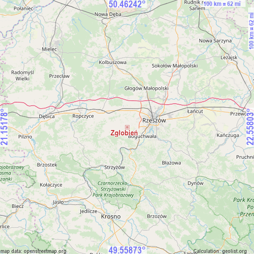
Zgłobień GPS coordinates[2]
50° 0' 45.72" North, 21° 51' 17.64" East
| Map corner | latitude | longitude |
|---|---|---|
| Upper-left | 50.46242°, | 21.15178° |
| Center: | 50.0127°, | 21.8549° |
| Lower-right: | 49.55873°, | 22.55803° |
| Map W x H: | 100.5×100.5 km | = 62.4×62.4mi |
| max Lat: | 54.83135° ⇑81.8% North |
| Zgłobień: | 50.0127° |
| min Lat: | ⇓18.2% South 49.21328° |
| min Long | Zgłobień | max Long |
| 14.20249° | 21.8549° | 24.03723° |
| W 82.9%⇐ | ⇒17.1% E |
Elevation
Elevation of Zgłobień is 231 m = 758 ft, and this is 39.6 m = 130 ft above average elevation for this country.
| Max E: |
974 m = 3196 ft | 29.4% |
| Zgłobień | 231 m 758 ft | |
| Avg. | 191.4 m = 628 ft | |
Min E: |
-3 m = -10 ft | 70.6% |
See also: Poland elevation on elevation.city.
Geographical zone
Zgłobień is located in North temperate zone (between Tropic of Cancer and the Arctic Circle). Distance of this North polar circle is 1840.3 km =1143.5 mi to North.| Distance of | km | miles | from Zgłobień |
|---|---|---|---|
| North Pole | 4446.2 | 2762.7 | to North |
| Arctic Circle | 1840.3 | 1143.5 | to North |
| Tropic Cancer | 2955 | 1836.2 | to South |
| Equator | 5560.9 | 3455.4 | to South |


Nearby cities:
15 places around Zgłobień: (largest is in red/bold)
• Babica
8.7 km =5.4 mi,  172°
172°
• Boguchwała
7.2 km =4.5 mi,  115°
115°
• Bystrzyca
9.8 km =6.1 mi,  246°
246°
• Czudec
7.6 km =4.7 mi,  187°
187°
• Iwierzyce
7.5 km =4.7 mi,  284°
284°
• Kielanówka
5.5 km =3.4 mi,  74°
74°
• Lubenia
10.5 km =6.5 mi,  150°
150°
• Lutoryż
6.5 km =4 mi,  140°
140°
• Niechobrz
2.6 km =1.6 mi, 140°
• Przybyszówka
6.4 km =4 mi,  52°
52°
• Siedliska
9.3 km =5.8 mi,  134°
134°
• Trzciana
6.7 km =4.2 mi,  349°
349°
• Wiśniowa
7.4 km =4.6 mi,  257°
257°
• Zarzecze
8.2 km =5.1 mi, 146°
• Świlcza
7.3 km =4.5 mi,  25°
25°
Sources, notices
• [Note1] Compared only with cities in Poland existing in our database
• [Src1] Map data: © OpenStreetMap contributors (CC-BY-SA)
• [Src2] Other city data from geonames.org with taken over terms of usage.
• [Src3] Geographical zone / Annual Mean Temperature by Robert A. Rohde @ Wikipedia
