Boguchwała geodata
Boguchwała (Subcarpathian) is a seat of a third-order administrative division; located in Poland in Europe/Warsaw (GMT+2) time zone. With population of 5,823 people, there are 618 cities with bigger population in this country. Compared to other cities in Poland, 83.5% of cities are located further ↑North; 84.1% of cities are located further ←West and 67.7% of cities have lower elevation than Boguchwała. Note1


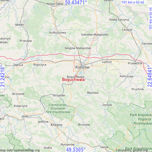
Boguchwała GPS coordinates[2]
49° 59' 5.028" North, 21° 56' 43.008" East
| Map corner | latitude | longitude |
|---|---|---|
| Upper-left | 50.43471°, | 21.24216° |
| Center: | 49.98473°, | 21.94528° |
| Lower-right: | 49.5305°, | 22.64841° |
| Map W x H: | 100.5×100.5 km | = 62.4×62.4mi |
| max Lat: | 54.83135° ⇑83.5% North |
| Boguchwała: | 49.98473° |
| min Lat: | ⇓16.5% South 49.21328° |
| min Long | Boguchwała | max Long |
| 14.20249° | 21.94528° | 24.03723° |
| W 84.1%⇐ | ⇒15.9% E |
Elevation
Elevation of Boguchwała is 222 m = 728 ft, and this is 30.6 m = 100 ft above average elevation for this country.
| Max E: |
974 m = 3196 ft | 32.3% |
| Boguchwała | 222 m 728 ft | |
| Avg. | 191.4 m = 628 ft | |
Min E: |
-3 m = -10 ft | 67.7% |
See also: Poland elevation on elevation.city.
Geographical zone
Boguchwała is located in North temperate zone (between Tropic of Cancer and the Arctic Circle). Distance of this North polar circle is 1843.4 km =1145.4 mi to North.| Distance of | km | miles | from Boguchwała |
|---|---|---|---|
| North Pole | 4449.3 | 2764.7 | to North |
| Arctic Circle | 1843.4 | 1145.4 | to North |
| Tropic Cancer | 2951.9 | 1834.2 | to South |
| Equator | 5557.8 | 3453.5 | to South |


Nearby cities:
15 places around Boguchwała: (largest is in red/bold)
• Babica
7.7 km =4.8 mi,  223°
223°
• Czudec
8.7 km =5.4 mi,  239°
239°
• Kielanówka
4.8 km =3 mi,  345°
345°
• Lubenia
6.1 km =3.8 mi,  192°
192°
• Lutoryż
3.1 km =1.9 mi,  230°
230°
• Niechobrz
4.9 km =3 mi,  283°
283°
• Połomia
9.7 km =6 mi,  203°
203°
• Przybyszówka
7.2 km =4.5 mi, 348°
• Rzeszów
7.4 km =4.6 mi,  31°
31°
• Siedliska
3.4 km =2.1 mi,  177°
177°
• Straszydle
9.7 km =6 mi,  164°
164°
• Tyczyn
6.8 km =4.2 mi,  110°
110°
• Zarzecze
4.2 km =2.6 mi,  207°
207°
• Zgłobień
7.2 km =4.5 mi,  295°
295°
• Świlcza
10.3 km =6.4 mi,  340°
340°
Sources, notices
• [Note1] Compared only with cities in Poland existing in our database
• [Src1] Map data: © OpenStreetMap contributors (CC-BY-SA)
• [Src2] Other city data from geonames.org with taken over terms of usage.
• [Src3] Geographical zone / Annual Mean Temperature by Robert A. Rohde @ Wikipedia
