Kielanówka geodata
Kielanówka (Subcarpathian) is a populated place; located in Poland in Europe/Warsaw (GMT+2) time zone. With population of 1,081 people, there are 2378 cities with bigger population in this country. Compared to other cities in Poland, 81.1% of cities are located further ↑North; 83.9% of cities are located further ←West and 84.4% of cities have lower elevation than Kielanówka. Note1


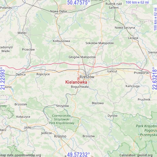
Kielanówka GPS coordinates[2]
50° 1' 34.176" North, 21° 55' 44.58" East
| Map corner | latitude | longitude |
|---|---|---|
| Upper-left | 50.47575°, | 21.22593° |
| Center: | 50.02616°, | 21.92905° |
| Lower-right: | 49.57232°, | 22.63218° |
| Map W x H: | 100.5×100.5 km | = 62.4×62.4mi |
| max Lat: | 54.83135° ⇑81.1% North |
| Kielanówka: | 50.02616° |
| min Lat: | ⇓18.9% South 49.21328° |
| min Long | Kielanówka | max Long |
| 14.20249° | 21.92905° | 24.03723° |
| W 83.9%⇐ | ⇒16.1% E |
Elevation
Elevation of Kielanówka is 287 m = 942 ft, and this is 95.6 m = 314 ft above average elevation for this country.
| Max E: |
974 m = 3196 ft | 15.6% |
| Kielanówka | 287 m 942 ft | |
| Avg. | 191.4 m = 628 ft | |
Min E: |
-3 m = -10 ft | 84.4% |
See also: Poland elevation on elevation.city.
Geographical zone
Kielanówka is located in North temperate zone (between Tropic of Cancer and the Arctic Circle). Distance of this North polar circle is 1838.8 km =1142.6 mi to North.| Distance of | km | miles | from Kielanówka |
|---|---|---|---|
| North Pole | 4444.7 | 2761.8 | to North |
| Arctic Circle | 1838.8 | 1142.6 | to North |
| Tropic Cancer | 2956.5 | 1837.1 | to South |
| Equator | 5562.4 | 3456.3 | to South |


Nearby cities:
15 places around Kielanówka: (largest is in red/bold)
• Boguchwała
4.8 km =3 mi,  165°
165°
• Lubenia
10.6 km =6.6 mi,  180°
180°
• Lutoryż
6.7 km =4.2 mi,  190°
190°
• Niechobrz
5 km =3.1 mi,  226°
226°
• Przybyszówka
2.4 km =1.5 mi,  354°
354°
• Rudna Mała
8.4 km =5.2 mi,  15°
15°
• Rudna Wielka
7 km =4.3 mi,  10°
10°
• Rzeszów
5.3 km =3.3 mi,  71°
71°
• Siedliska
8.1 km =5 mi, 170°
• Trzciana
8.2 km =5.1 mi,  308°
308°
• Trzebownisko
9.7 km =6 mi,  53°
53°
• Tyczyn
10.2 km =6.3 mi,  132°
132°
• Zarzecze
8.4 km =5.2 mi, 185°
• Zgłobień
5.5 km =3.4 mi,  254°
254°
• Świlcza
5.5 km =3.4 mi,  336°
336°
Sources, notices
• [Note1] Compared only with cities in Poland existing in our database
• [Src1] Map data: © OpenStreetMap contributors (CC-BY-SA)
• [Src2] Other city data from geonames.org with taken over terms of usage.
• [Src3] Geographical zone / Annual Mean Temperature by Robert A. Rohde @ Wikipedia
