Rzeszów geodata
Rzeszów (Subcarpathian) is a seat of a first-order administrative division; located in Poland in Europe/Warsaw (GMT+2) time zone. With population of 158,382 people, there are 24 cities with bigger population in this country. Compared to other cities in Poland, 80.5% of cities are located further ↑North; 84.8% of cities are located further ←West and 63% of cities have lower elevation than Rzeszów. Note1


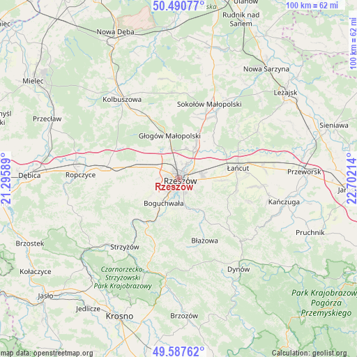
Rzeszów GPS coordinates[2]
50° 2' 28.752" North, 21° 59' 56.436" East
| Map corner | latitude | longitude |
|---|---|---|
| Upper-left | 50.49077°, | 21.29589° |
| Center: | 50.04132°, | 21.99901° |
| Lower-right: | 49.58762°, | 22.70214° |
| Map W x H: | 100.4×100.4 km | = 62.4×62.4mi |
| max Lat: | 54.83135° ⇑80.5% North |
| Rzeszów: | 50.04132° |
| min Lat: | ⇓19.5% South 49.21328° |
| min Long | Rzeszów | max Long |
| 14.20249° | 21.99901° | 24.03723° |
| W 84.8%⇐ | ⇒15.2% E |
Elevation
Elevation of Rzeszów is 209 m = 686 ft, and this is 17.6 m = 58 ft above average elevation for this country.
| Max E: |
974 m = 3196 ft | 37% |
| Rzeszów | 209 m 686 ft | |
| Avg. | 191.4 m = 628 ft | |
Min E: |
-3 m = -10 ft | 63% |
See also: Rzeszów elevation on elevation.city.
Geographical zone
Rzeszów is located in North temperate zone (between Tropic of Cancer and the Arctic Circle). Distance of this North polar circle is 1837.1 km =1141.5 mi to North.| Distance of | km | miles | from Rzeszów |
|---|---|---|---|
| North Pole | 4443 | 2760.8 | to North |
| Arctic Circle | 1837.1 | 1141.5 | to North |
| Tropic Cancer | 2958.2 | 1838.1 | to South |
| Equator | 5564.1 | 3457.4 | to South |


Nearby cities:
15 places around Rzeszów: (largest is in red/bold)
• Boguchwała
7.4 km =4.6 mi,  211°
211°
• Kielanówka
5.3 km =3.3 mi,  251°
251°
• Krasne
6.5 km =4 mi,  75°
75°
• Lutoryż
10.3 km =6.4 mi,  216°
216°
• Niechobrz
10.1 km =6.3 mi,  239°
239°
• Przybyszówka
5.3 km =3.3 mi,  277°
277°
• Rudna Mała
7 km =4.3 mi,  336°
336°
• Rudna Wielka
6.4 km =4 mi,  324°
324°
• Siedliska
10.4 km =6.5 mi,  200°
200°
• Trzebownisko
4.9 km =3 mi,  33°
33°
• Tyczyn
9 km =5.6 mi,  163°
163°
• Wólka Podleśna
11.7 km =7.3 mi,  43°
43°
• Zarzecze
11.6 km =7.2 mi, 210°
• Zgłobień
10.8 km =6.7 mi, 252°
• Świlcza
8 km =5 mi,  295°
295°
Sources, notices
• [Note1] Compared only with cities in Poland existing in our database
• [Src1] Map data: © OpenStreetMap contributors (CC-BY-SA)
• [Src2] Other city data from geonames.org with taken over terms of usage.
• [Src3] Geographical zone / Annual Mean Temperature by Robert A. Rohde @ Wikipedia
