Niechobrz geodata
Niechobrz (Subcarpathian) is a populated place; located in Poland in Europe/Warsaw (GMT+2) time zone. With population of 2,644 people, there are 1190 cities with bigger population in this country. Compared to other cities in Poland, 82.8% of cities are located further ↑North; 83.1% of cities are located further ←West and 69.8% of cities have lower elevation than Niechobrz. Note1


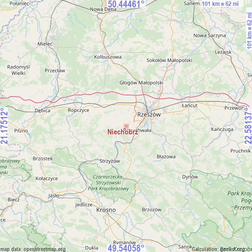
Niechobrz GPS coordinates[2]
49° 59' 40.992" North, 21° 52' 41.664" East
| Map corner | latitude | longitude |
|---|---|---|
| Upper-left | 50.44461°, | 21.17512° |
| Center: | 49.99472°, | 21.87824° |
| Lower-right: | 49.54058°, | 22.58137° |
| Map W x H: | 100.5×100.5 km | = 62.4×62.4mi |
| max Lat: | 54.83135° ⇑82.8% North |
| Niechobrz: | 49.99472° |
| min Lat: | ⇓17.2% South 49.21328° |
| min Long | Niechobrz | max Long |
| 14.20249° | 21.87824° | 24.03723° |
| W 83.1%⇐ | ⇒16.9% E |
Elevation
Elevation of Niechobrz is 229 m = 751 ft, and this is 37.6 m = 123 ft above average elevation for this country.
| Max E: |
974 m = 3196 ft | 30.2% |
| Niechobrz | 229 m 751 ft | |
| Avg. | 191.4 m = 628 ft | |
Min E: |
-3 m = -10 ft | 69.8% |
See also: Poland elevation on elevation.city.
Geographical zone
Niechobrz is located in North temperate zone (between Tropic of Cancer and the Arctic Circle). Distance of this North polar circle is 1842.3 km =1144.8 mi to North.| Distance of | km | miles | from Niechobrz |
|---|---|---|---|
| North Pole | 4448.2 | 2764 | to North |
| Arctic Circle | 1842.3 | 1144.8 | to North |
| Tropic Cancer | 2953 | 1834.9 | to South |
| Equator | 5558.9 | 3454.1 | to South |


Nearby cities:
15 places around Niechobrz: (largest is in red/bold)
• Babica
6.7 km =4.2 mi,  184°
184°
• Boguchwała
4.9 km =3 mi,  103°
103°
• Czudec
6.1 km =3.8 mi,  205°
205°
• Iwierzyce
9.7 km =6 mi,  293°
293°
• Kielanówka
5 km =3.1 mi,  46°
46°
• Lubenia
7.9 km =4.9 mi,  154°
154°
• Lutoryż
3.9 km =2.4 mi,  141°
141°
• Przybyszówka
6.8 km =4.2 mi,  29°
29°
• Rzeszów
10.1 km =6.3 mi,  59°
59°
• Siedliska
6.7 km =4.2 mi,  132°
132°
• Trzciana
9 km =5.6 mi,  341°
341°
• Wiśniowa
8.9 km =5.5 mi,  272°
272°
• Zarzecze
5.6 km =3.5 mi, 149°
• Zgłobień
2.6 km =1.6 mi,  320°
320°
• Świlcza
8.7 km =5.4 mi,  9°
9°
Sources, notices
• [Note1] Compared only with cities in Poland existing in our database
• [Src1] Map data: © OpenStreetMap contributors (CC-BY-SA)
• [Src2] Other city data from geonames.org with taken over terms of usage.
• [Src3] Geographical zone / Annual Mean Temperature by Robert A. Rohde @ Wikipedia
