Sulejówek geodata
Sulejówek (Mazovia) is a seat of a third-order administrative division; located in Poland in Europe/Warsaw (GMT+2) time zone. With population of 18,414 people, there are 266 cities with bigger population in this country. Compared to other cities in Poland, 71.4% of cities are located further ↓South; 76.6% of cities are located further ←West and 77.6% of cities have higher elevation than Sulejówek. Note1


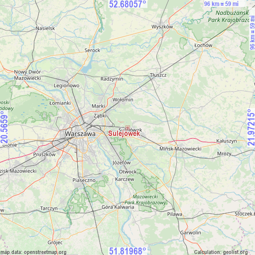
Sulejówek GPS coordinates[2]
52° 15' 7.956" North, 21° 16' 8.472" East
| Map corner | latitude | longitude |
|---|---|---|
| Upper-left | 52.68057°, | 20.5659° |
| Center: | 52.25221°, | 21.26902° |
| Lower-right: | 51.81968°, | 21.97215° |
| Map W x H: | 95.7×95.7 km | = 59.5×59.5mi |
| max Lat: | 54.83135° ⇑28.6% North |
| Sulejówek: | 52.25221° |
| min Lat: | ⇓71.4% South 49.21328° |
| min Long | Sulejówek | max Long |
| 14.20249° | 21.26902° | 24.03723° |
| W 76.6%⇐ | ⇒23.4% E |
Elevation
Elevation of Sulejówek is 104 m = 341 ft, and this is 87.4 m = 287 ft below average elevation for this country.
| Max E: |
974 m = 3196 ft | 77.6% |
| Avg. | 191.4 m = 628 ft | |
| Sulejówek | 104 m = 341 ft | |
Min E: |
-3 m = -10 ft | 22.4% |
See also: Poland elevation on elevation.city.
Geographical zone
Sulejówek is located in North temperate zone (between Tropic of Cancer and the Arctic Circle). Distance of this North polar circle is 1591.3 km =988.8 mi to North.| Distance of | km | miles | from Sulejówek |
|---|---|---|---|
| North Pole | 4197.2 | 2608 | to North |
| Arctic Circle | 1591.3 | 988.8 | to North |
| Tropic Cancer | 3204 | 1990.9 | to South |
| Equator | 5809.9 | 3610.1 | to South |


Nearby cities:
15 places around Sulejówek: (largest is in red/bold)
• Czarna
13.2 km =8.2 mi,  347°
347°
• Duczki
12.4 km =7.7 mi,  6°
6°
• Dębe Wielkie
13.2 km =8.2 mi,  116°
116°
• Halinów
6.4 km =4 mi,  113°
113°
• Józefów
13 km =8.1 mi,  190°
190°
• Kobyłka
10.9 km =6.8 mi,  332°
332°
• Nowe Lipiny
11.8 km =7.3 mi,  0°
0°
• Praga Południe
12.5 km =7.8 mi,  265°
265°
• Rembertów
7.2 km =4.5 mi,  277°
277°
• Wawer
8.8 km =5.5 mi,  225°
225°
• Wesoła
3.1 km =1.9 mi, 274°
• Wiązowna
9.2 km =5.7 mi,  170°
170°
• Wołomin
9.9 km =6.2 mi, 349°
• Zielonka
9.4 km =5.8 mi,  307°
307°
• Ząbki
12 km =7.5 mi,  292°
292°
Sources, notices
• [Note1] Compared only with cities in Poland existing in our database
• [Src1] Map data: © OpenStreetMap contributors (CC-BY-SA)
• [Src2] Other city data from geonames.org with taken over terms of usage.
• [Src3] Geographical zone / Annual Mean Temperature by Robert A. Rohde @ Wikipedia
