Telatyn geodata
Telatyn (Lublin) is a seat of a third-order administrative division; located in Poland in Europe/Warsaw (GMT+2) time zone. With population of 603 people, there are 3266 cities with bigger population in this country. Compared to other cities in Poland, 66.8% of cities are located further ↑North; 99.8% of cities are located further ←West and 65.9% of cities have lower elevation than Telatyn. Note1


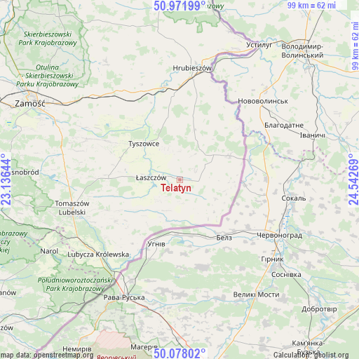
Telatyn GPS coordinates[2]
50° 31' 37.632" North, 23° 50' 22.416" East
| Map corner | latitude | longitude |
|---|---|---|
| Upper-left | 50.97199°, | 23.13644° |
| Center: | 50.52712°, | 23.83956° |
| Lower-right: | 50.07802°, | 24.54269° |
| Map W x H: | 99.4×99.4 km | = 61.8×61.8mi |
| max Lat: | 54.83135° ⇑66.8% North |
| Telatyn: | 50.52712° |
| min Lat: | ⇓33.2% South 49.21328° |
| min Long | Telatyn | max Long |
| 14.20249° | 23.83956° | 24.03723° |
| W 99.8%⇐ | ⇒0.2% E |
Elevation
Elevation of Telatyn is 216 m = 709 ft, and this is 24.6 m = 81 ft above average elevation for this country.
| Max E: |
974 m = 3196 ft | 34.1% |
| Telatyn | 216 m 709 ft | |
| Avg. | 191.4 m = 628 ft | |
Min E: |
-3 m = -10 ft | 65.9% |
See also: Poland elevation on elevation.city.
Geographical zone
Telatyn is located in North temperate zone (between Tropic of Cancer and the Arctic Circle). Distance of this North polar circle is 1783.1 km =1108 mi to North.| Distance of | km | miles | from Telatyn |
|---|---|---|---|
| North Pole | 4389 | 2727.2 | to North |
| Arctic Circle | 1783.1 | 1108 | to North |
| Tropic Cancer | 3012.2 | 1871.7 | to South |
| Equator | 5618.1 | 3490.9 | to South |


Nearby cities:
15 places around Telatyn: (largest is in red/bold)
• Bełżec
32.5 km =20.2 mi,  240°
240°
• Dołhobyczów
15.3 km =9.5 mi,  64°
64°
• Hrubieszów
31.1 km =19.3 mi,  6°
6°
• Jarczów
21.3 km =13.2 mi, 237°
• Komarów-Osada
28 km =17.4 mi,  293°
293°
• Lubycza Królewska
30.7 km =19.1 mi,  227°
227°
• Michałów
16.8 km =10.4 mi,  277°
277°
• Mircze
14.4 km =8.9 mi,  16°
16°
• Rachanie
20.7 km =12.9 mi,  273°
273°
• Tarnawatka
31.4 km =19.5 mi, 270°
• Tomaszów Lubelski
31.2 km =19.4 mi,  253°
253°
• Tyszowce
14.1 km =8.8 mi,  315°
315°
• Ulhówek
9.1 km =5.7 mi,  198°
198°
• Werbkowice
25.8 km =16 mi,  348°
348°
• Łaszczów
8.1 km =5 mi, 274°
Sources, notices
• [Note1] Compared only with cities in Poland existing in our database
• [Src1] Map data: © OpenStreetMap contributors (CC-BY-SA)
• [Src2] Other city data from geonames.org with taken over terms of usage.
• [Src3] Geographical zone / Annual Mean Temperature by Robert A. Rohde @ Wikipedia
