Bolimów geodata
Bolimów (Łódź Voivodeship) is a seat of a third-order administrative division; located in Poland in Europe/Warsaw (GMT+2) time zone. With population of 930 people, there are 2620 cities with bigger population in this country. Compared to other cities in Poland, 67.2% of cities are located further ↓South; 60.9% of cities are located further ←West and 85.2% of cities have higher elevation than Bolimów. Note1
Administrative division(s):
- Level 1: Łódź Voivodeship
- Level 2: Powiat skierniewicki
- Level 3: Bolimów


Bolimów GPS coordinates[2]
52° 4' 36.156" North, 20° 9' 48.672" East
| Map corner | latitude | longitude |
|---|---|---|
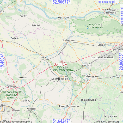
| Upper-left | 52.50677°, | 19.4604° |
| Center: | 52.07671°, | 20.16352° |
| Lower-right: | 51.64247°, | 20.86665° |
| Map W x H: | 96.1×96.1 km | = 59.7×59.7mi |
| max Lat: | 54.83135° ⇑32.8% North |
| Bolimów: | 52.07671° |
| min Lat: | ⇓67.2% South 49.21328° |
| min Long | Bolimów | max Long |
| 14.20249° | 20.16352° | 24.03723° |
| W 60.9%⇐ | ⇒39.1% E |
Elevation
Elevation of Bolimów is 89 m = 292 ft, and this is 102.4 m = 336 ft below average elevation for this country.
| Max E: |
974 m = 3196 ft | 85.2% |
| Avg. | 191.4 m = 628 ft | |
| Bolimów | 89 m = 292 ft | |
Min E: |
-3 m = -10 ft | 14.8% |
See also: Poland elevation on elevation.city.
Geographical zone
Bolimów is located in North temperate zone (between Tropic of Cancer and the Arctic Circle). Distance of this North polar circle is 1610.8 km =1000.9 mi to North.| Distance of | km | miles | from Bolimów |
|---|---|---|---|
| North Pole | 4216.7 | 2620.1 | to North |
| Arctic Circle | 1610.8 | 1000.9 | to North |
| Tropic Cancer | 3184.5 | 1978.8 | to South |
| Equator | 5790.4 | 3598 | to South |


Nearby cities:
15 places around Bolimów: (largest is in red/bold)
• Bobrowniki
9.9 km =6.2 mi,  262°
262°
• Czerwonka-Parcel
16.9 km =10.5 mi,  24°
24°
• Franciszków
13 km =8.1 mi,  118°
118°
• Guzów
12.6 km =7.8 mi,  69°
69°
• Jesionka
14.3 km =8.9 mi,  114°
114°
• Kozłów Biskupi
12.9 km =8 mi,  8°
8°
• Maków
16.3 km =10.1 mi,  207°
207°
• Miedniewice
9.5 km =5.9 mi,  85°
85°
• Miedniewice
13.6 km =8.5 mi,  170°
170°
• Mrozy
15.3 km =9.5 mi, 114°
• Nieborów
6.5 km =4 mi,  270°
270°
• Puszcza Mariańska
16.8 km =10.4 mi,  130°
130°
• Skierniewice
13.6 km =8.5 mi,  181°
181°
• Wiskitki
15.3 km =9.5 mi, 85°
• Łowicz
15.3 km =9.5 mi,  282°
282°
Sources, notices
• [Note1] Compared only with cities in Poland existing in our database
• [Src1] Map data: © OpenStreetMap contributors (CC-BY-SA)
• [Src2] Other city data from geonames.org with taken over terms of usage.
• [Src3] Geographical zone / Annual Mean Temperature by Robert A. Rohde @ Wikipedia
