Przychojec geodata
Przychojec (Subcarpathian) is a populated place; located in Poland in Europe/Warsaw (GMT+2) time zone. With population of 1,000 people, there are 2459 cities with bigger population in this country. Compared to other cities in Poland, 72.1% of cities are located further ↑North; 90.2% of cities are located further ←West and 52.1% of cities have higher elevation than Przychojec. Note1


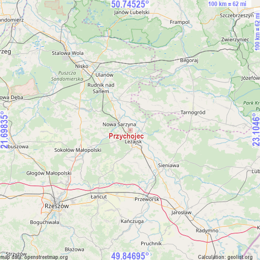
Przychojec GPS coordinates[2]
50° 17' 53.592" North, 22° 24' 5.292" East
| Map corner | latitude | longitude |
|---|---|---|
| Upper-left | 50.74525°, | 21.69835° |
| Center: | 50.29822°, | 22.40147° |
| Lower-right: | 49.84695°, | 23.1046° |
| Map W x H: | 99.9×99.9 km | = 62.1×62.1mi |
| max Lat: | 54.83135° ⇑72.1% North |
| Przychojec: | 50.29822° |
| min Lat: | ⇓27.9% South 49.21328° |
| min Long | Przychojec | max Long |
| 14.20249° | 22.40147° | 24.03723° |
| W 90.2%⇐ | ⇒9.8% E |
Elevation
Elevation of Przychojec is 166 m = 545 ft, and this is 25.4 m = 83 ft below average elevation for this country.
| Max E: |
974 m = 3196 ft | 52.1% |
| Avg. | 191.4 m = 628 ft | |
| Przychojec | 166 m = 545 ft | |
Min E: |
-3 m = -10 ft | 47.9% |
See also: Poland elevation on elevation.city.
Geographical zone
Przychojec is located in North temperate zone (between Tropic of Cancer and the Arctic Circle). Distance of this North polar circle is 1808.5 km =1123.7 mi to North.| Distance of | km | miles | from Przychojec |
|---|---|---|---|
| North Pole | 4414.4 | 2743 | to North |
| Arctic Circle | 1808.5 | 1123.7 | to North |
| Tropic Cancer | 2986.7 | 1855.8 | to South |
| Equator | 5592.6 | 3475.1 | to South |


Nearby cities:
15 places around Przychojec: (largest is in red/bold)
• Brzóza Królewska
8.5 km =5.3 mi,  219°
219°
• Bystre
9 km =5.6 mi,  357°
357°
• Giedlarowa
7.9 km =4.9 mi,  177°
177°
• Hucisko
7.6 km =4.7 mi,  252°
252°
• Kuryłówka
4.6 km =2.9 mi,  87°
87°
• Leżajsk
4.2 km =2.6 mi,  162°
162°
• Nowa Sarzyna
4.8 km =3 mi,  301°
301°
• Piskorowice
11.4 km =7.1 mi,  127°
127°
• Stare Miasto
2.2 km =1.4 mi,  117°
117°
• Tarnogóra
9.8 km =6.1 mi,  322°
322°
• Wierzawice
7.7 km =4.8 mi,  152°
152°
• Wola Żarczycka
10.8 km =6.7 mi,  265°
265°
• Wólka Grodziska
12.1 km =7.5 mi, 179°
• Łukowa
3.7 km =2.3 mi, 323°
• Łętownia
12.3 km =7.6 mi,  283°
283°
Sources, notices
• [Note1] Compared only with cities in Poland existing in our database
• [Src1] Map data: © OpenStreetMap contributors (CC-BY-SA)
• [Src2] Other city data from geonames.org with taken over terms of usage.
• [Src3] Geographical zone / Annual Mean Temperature by Robert A. Rohde @ Wikipedia
