Jabłonna geodata
Jabłonna (Lublin) is a seat of a third-order administrative division; located in Poland in Europe/Warsaw (GMT+2) time zone. With population of 2,041 people, there are 1453 cities with bigger population in this country. Compared to other cities in Poland, 53% of cities are located further ↑North; 92.7% of cities are located further ←West and 64.1% of cities have lower elevation than Jabłonna. Note1


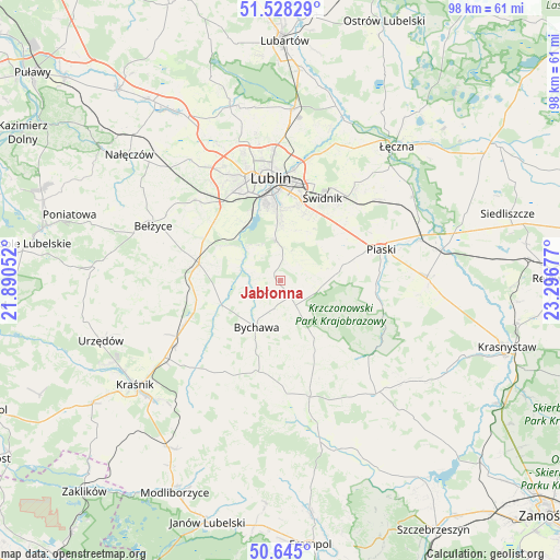
Jabłonna GPS coordinates[2]
51° 5' 19.5" North, 22° 35' 37.104" East
| Map corner | latitude | longitude |
|---|---|---|
| Upper-left | 51.52829°, | 21.89052° |
| Center: | 51.08875°, | 22.59364° |
| Lower-right: | 50.645°, | 23.29677° |
| Map W x H: | 98.2×98.2 km | = 61×61mi |
| max Lat: | 54.83135° ⇑53% North |
| Jabłonna: | 51.08875° |
| min Lat: | ⇓47% South 49.21328° |
| min Long | Jabłonna | max Long |
| 14.20249° | 22.59364° | 24.03723° |
| W 92.7%⇐ | ⇒7.3% E |
Elevation
Elevation of Jabłonna is 212 m = 696 ft, and this is 20.6 m = 68 ft above average elevation for this country.
| Max E: |
974 m = 3196 ft | 35.9% |
| Jabłonna | 212 m 696 ft | |
| Avg. | 191.4 m = 628 ft | |
Min E: |
-3 m = -10 ft | 64.1% |
See also: Poland elevation on elevation.city.
Geographical zone
Jabłonna is located in North temperate zone (between Tropic of Cancer and the Arctic Circle). Distance of this North polar circle is 1720.6 km =1069.1 mi to North.| Distance of | km | miles | from Jabłonna |
|---|---|---|---|
| North Pole | 4326.5 | 2688.4 | to North |
| Arctic Circle | 1720.6 | 1069.1 | to North |
| Tropic Cancer | 3074.6 | 1910.5 | to South |
| Equator | 5680.5 | 3529.7 | to South |


Nearby cities:
15 places around Jabłonna: (largest is in red/bold)
• Bychawa
9.1 km =5.7 mi,  207°
207°
• Bystrzyca
17 km =10.6 mi,  229°
229°
• Konopnica
18.1 km =11.2 mi,  329°
329°
• Kozubszczyzna
18.9 km =11.7 mi,  322°
322°
• Krzczonów
12.2 km =7.6 mi,  137°
137°
• Lublin
18 km =11.2 mi,  354°
354°
• Niedrzwica Duża
14.6 km =9.1 mi,  281°
281°
• Piaski
18.6 km =11.6 mi,  72°
72°
• Rudnik Pierwszy
17.8 km =11.1 mi,  217°
217°
• Rybczewice
19.2 km =11.9 mi,  110°
110°
• Strzyżowice
11.6 km =7.2 mi,  247°
247°
• Wilkołaz
18.9 km =11.7 mi,  244°
244°
• Wólka
19.8 km =12.3 mi,  9°
9°
• Świdnik
16.2 km =10.1 mi,  26°
26°
• Żabia Wola
6.5 km =4 mi,  302°
302°
Sources, notices
• [Note1] Compared only with cities in Poland existing in our database
• [Src1] Map data: © OpenStreetMap contributors (CC-BY-SA)
• [Src2] Other city data from geonames.org with taken over terms of usage.
• [Src3] Geographical zone / Annual Mean Temperature by Robert A. Rohde @ Wikipedia
