Ożarów geodata
Ożarów (Lublin) is a populated place; located in Poland in Europe/Warsaw (GMT+2) time zone. With population of 650 people, there are 3162 cities with bigger population in this country. Compared to other cities in Poland, 53% of cities are located further ↓South; 88.8% of cities are located further ←West and 60.6% of cities have lower elevation than Ożarów. Note1


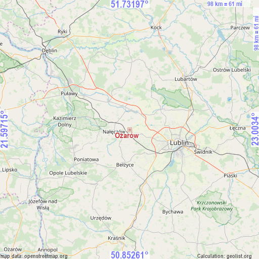
Ożarów GPS coordinates[2]
51° 17' 39.84" North, 22° 18' 0.972" East
| Map corner | latitude | longitude |
|---|---|---|
| Upper-left | 51.73197°, | 21.59715° |
| Center: | 51.2944°, | 22.30027° |
| Lower-right: | 50.85261°, | 23.0034° |
| Map W x H: | 97.8×97.8 km | = 60.8×60.8mi |
| max Lat: | 54.83135° ⇑47% North |
| Ożarów: | 51.2944° |
| min Lat: | ⇓53% South 49.21328° |
| min Long | Ożarów | max Long |
| 14.20249° | 22.30027° | 24.03723° |
| W 88.8%⇐ | ⇒11.2% E |
Elevation
Elevation of Ożarów is 202 m = 663 ft, and this is 10.6 m = 35 ft above average elevation for this country.
| Max E: |
974 m = 3196 ft | 39.4% |
| Ożarów | 202 m 663 ft | |
| Avg. | 191.4 m = 628 ft | |
Min E: |
-3 m = -10 ft | 60.6% |
See also: Poland elevation on elevation.city.
Geographical zone
Ożarów is located in North temperate zone (between Tropic of Cancer and the Arctic Circle). Distance of this North polar circle is 1697.8 km =1055 mi to North.| Distance of | km | miles | from Ożarów |
|---|---|---|---|
| North Pole | 4303.7 | 2674.2 | to North |
| Arctic Circle | 1697.8 | 1055 | to North |
| Tropic Cancer | 3097.5 | 1924.7 | to South |
| Equator | 5703.4 | 3543.9 | to South |


Nearby cities:
15 places around Ożarów: (largest is in red/bold)
• Abramów
18.1 km =11.2 mi,  3°
3°
• Bełżyce
13.4 km =8.3 mi,  185°
185°
• Brzozowa Gać
14.2 km =8.8 mi,  323°
323°
• Garbów
7.1 km =4.4 mi,  16°
16°
• Jastków
9.5 km =5.9 mi,  83°
83°
• Konopnica
13.4 km =8.3 mi,  123°
123°
• Kozubszczyzna
11.9 km =7.4 mi,  131°
131°
• Kurów
13.2 km =8.2 mi, 323°
• Lublin
19.2 km =11.9 mi,  104°
104°
• Markuszów
9.4 km =5.8 mi,  341°
341°
• Nałęczów
6 km =3.7 mi,  260°
260°
• Poniatowa
17.4 km =10.8 mi,  222°
222°
• Przybysławice
8.4 km =5.2 mi,  350°
350°
• Wojciechów
7.6 km =4.7 mi,  210°
210°
• Wąwolnica
10.7 km =6.6 mi,  270°
270°
Sources, notices
• [Note1] Compared only with cities in Poland existing in our database
• [Src1] Map data: © OpenStreetMap contributors (CC-BY-SA)
• [Src2] Other city data from geonames.org with taken over terms of usage.
• [Src3] Geographical zone / Annual Mean Temperature by Robert A. Rohde @ Wikipedia
