Jastków geodata
Jastków (Lublin) is a seat of a third-order administrative division; located in Poland in Europe/Warsaw (GMT+2) time zone. With population of 700 people, there are 3061 cities with bigger population in this country. Compared to other cities in Poland, 53.2% of cities are located further ↓South; 90.7% of cities are located further ←West and 62.8% of cities have lower elevation than Jastków. Note1


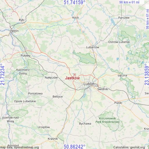
Jastków GPS coordinates[2]
51° 18' 14.796" North, 22° 26' 7.656" East
| Map corner | latitude | longitude |
|---|---|---|
| Upper-left | 51.74159°, | 21.73234° |
| Center: | 51.30411°, | 22.43546° |
| Lower-right: | 50.86242°, | 23.13859° |
| Map W x H: | 97.8×97.8 km | = 60.8×60.8mi |
| max Lat: | 54.83135° ⇑46.8% North |
| Jastków: | 51.30411° |
| min Lat: | ⇓53.2% South 49.21328° |
| min Long | Jastków | max Long |
| 14.20249° | 22.43546° | 24.03723° |
| W 90.7%⇐ | ⇒9.3% E |
Elevation
Elevation of Jastków is 208 m = 682 ft, and this is 16.6 m = 54 ft above average elevation for this country.
| Max E: |
974 m = 3196 ft | 37.2% |
| Jastków | 208 m 682 ft | |
| Avg. | 191.4 m = 628 ft | |
Min E: |
-3 m = -10 ft | 62.8% |
See also: Poland elevation on elevation.city.
Geographical zone
Jastków is located in North temperate zone (between Tropic of Cancer and the Arctic Circle). Distance of this North polar circle is 1696.7 km =1054.3 mi to North.| Distance of | km | miles | from Jastków |
|---|---|---|---|
| North Pole | 4302.6 | 2673.5 | to North |
| Arctic Circle | 1696.7 | 1054.3 | to North |
| Tropic Cancer | 3098.6 | 1925.4 | to South |
| Equator | 5704.5 | 3544.6 | to South |


Nearby cities:
15 places around Jastków: (largest is in red/bold)
• Bełżyce
18 km =11.2 mi,  216°
216°
• Garbów
9.3 km =5.8 mi,  307°
307°
• Jakubowice Murowane
14.3 km =8.9 mi,  105°
105°
• Kamionka
18.7 km =11.6 mi,  5°
5°
• Konopnica
8.6 km =5.3 mi,  168°
168°
• Kozubszczyzna
9 km =5.6 mi,  183°
183°
• Kozłówka
16.7 km =10.4 mi, 14°
• Lublin
10.9 km =6.8 mi,  123°
123°
• Markuszów
14.6 km =9.1 mi,  302°
302°
• Nałęczów
15.4 km =9.6 mi,  262°
262°
• Niemce
15.5 km =9.6 mi,  65°
65°
• Ożarów
9.5 km =5.9 mi, 263°
• Przybysławice
12.9 km =8 mi, 304°
• Wojciechów
15.3 km =9.5 mi,  239°
239°
• Wólka
14.8 km =9.2 mi, 107°
Sources, notices
• [Note1] Compared only with cities in Poland existing in our database
• [Src1] Map data: © OpenStreetMap contributors (CC-BY-SA)
• [Src2] Other city data from geonames.org with taken over terms of usage.
• [Src3] Geographical zone / Annual Mean Temperature by Robert A. Rohde @ Wikipedia
