Konopnica geodata
Konopnica (Lublin) is a populated place; located in Poland in Europe/Warsaw (GMT+2) time zone. With population of 740 people, there are 2992 cities with bigger population in this country. Compared to other cities in Poland, 51.5% of cities are located further ↓South; 91.1% of cities are located further ←West and 67.7% of cities have lower elevation than Konopnica. Note1


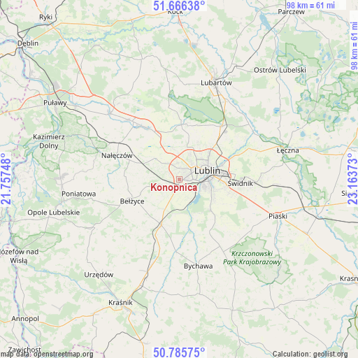
Konopnica GPS coordinates[2]
51° 13' 41.412" North, 22° 27' 38.16" East
| Map corner | latitude | longitude |
|---|---|---|
| Upper-left | 51.66638°, | 21.75748° |
| Center: | 51.22817°, | 22.4606° |
| Lower-right: | 50.78575°, | 23.16373° |
| Map W x H: | 97.9×97.9 km | = 60.8×60.8mi |
| max Lat: | 54.83135° ⇑48.5% North |
| Konopnica: | 51.22817° |
| min Lat: | ⇓51.5% South 49.21328° |
| min Long | Konopnica | max Long |
| 14.20249° | 22.4606° | 24.03723° |
| W 91.1%⇐ | ⇒8.9% E |
Elevation
Elevation of Konopnica is 222 m = 728 ft, and this is 30.6 m = 100 ft above average elevation for this country.
| Max E: |
974 m = 3196 ft | 32.3% |
| Konopnica | 222 m 728 ft | |
| Avg. | 191.4 m = 628 ft | |
Min E: |
-3 m = -10 ft | 67.7% |
See also: Poland elevation on elevation.city.
Geographical zone
Konopnica is located in North temperate zone (between Tropic of Cancer and the Arctic Circle). Distance of this North polar circle is 1705.1 km =1059.5 mi to North.| Distance of | km | miles | from Konopnica |
|---|---|---|---|
| North Pole | 4311 | 2678.7 | to North |
| Arctic Circle | 1705.1 | 1059.5 | to North |
| Tropic Cancer | 3090.1 | 1920.1 | to South |
| Equator | 5696 | 3539.3 | to South |


Nearby cities:
15 places around Konopnica: (largest is in red/bold)
• Bełżyce
13.9 km =8.6 mi,  244°
244°
• Garbów
16.8 km =10.4 mi,  327°
327°
• Jabłonna
18.1 km =11.2 mi,  149°
149°
• Jakubowice Murowane
12.9 km =8 mi,  68°
68°
• Jastków
8.6 km =5.3 mi,  348°
348°
• Kozubszczyzna
2.4 km =1.5 mi,  256°
256°
• Lublin
7.8 km =4.8 mi, 71°
• Nałęczów
18.2 km =11.3 mi,  290°
290°
• Niedrzwica Duża
13.6 km =8.5 mi,  201°
201°
• Niemce
19.4 km =12.1 mi,  39°
39°
• Ożarów
13.4 km =8.3 mi,  303°
303°
• Wojciechów
15 km =9.3 mi,  273°
273°
• Wólka
13 km =8.1 mi, 71°
• Świdnik
16.4 km =10.2 mi,  93°
93°
• Żabia Wola
12.6 km =7.8 mi,  162°
162°
Sources, notices
• [Note1] Compared only with cities in Poland existing in our database
• [Src1] Map data: © OpenStreetMap contributors (CC-BY-SA)
• [Src2] Other city data from geonames.org with taken over terms of usage.
• [Src3] Geographical zone / Annual Mean Temperature by Robert A. Rohde @ Wikipedia
