Nałęczów geodata
Nałęczów (Lublin) is a seat of a third-order administrative division; located in Poland in Europe/Warsaw (GMT+2) time zone. With population of 4,200 people, there are 778 cities with bigger population in this country. Compared to other cities in Poland, 52.8% of cities are located further ↓South; 87.5% of cities are located further ←West and 52.6% of cities have lower elevation than Nałęczów. Note1


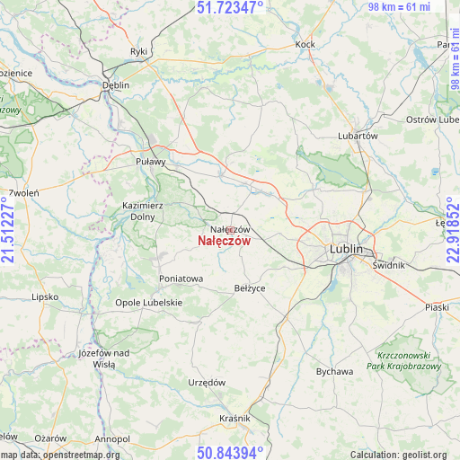
Nałęczów GPS coordinates[2]
51° 17' 8.916" North, 22° 12' 55.404" East
| Map corner | latitude | longitude |
|---|---|---|
| Upper-left | 51.72347°, | 21.51227° |
| Center: | 51.28581°, | 22.21539° |
| Lower-right: | 50.84394°, | 22.91852° |
| Map W x H: | 97.8×97.8 km | = 60.8×60.8mi |
| max Lat: | 54.83135° ⇑47.2% North |
| Nałęczów: | 51.28581° |
| min Lat: | ⇓52.8% South 49.21328° |
| min Long | Nałęczów | max Long |
| 14.20249° | 22.21539° | 24.03723° |
| W 87.5%⇐ | ⇒12.5% E |
Elevation
Elevation of Nałęczów is 179 m = 587 ft, and this is 12.4 m = 41 ft below average elevation for this country.
| Max E: |
974 m = 3196 ft | 47.4% |
| Avg. | 191.4 m = 628 ft | |
| Nałęczów | 179 m = 587 ft | |
Min E: |
-3 m = -10 ft | 52.6% |
See also: Poland elevation on elevation.city.
Geographical zone
Nałęczów is located in North temperate zone (between Tropic of Cancer and the Arctic Circle). Distance of this North polar circle is 1698.7 km =1055.5 mi to North.| Distance of | km | miles | from Nałęczów |
|---|---|---|---|
| North Pole | 4304.6 | 2674.8 | to North |
| Arctic Circle | 1698.7 | 1055.5 | to North |
| Tropic Cancer | 3096.5 | 1924.1 | to South |
| Equator | 5702.4 | 3543.3 | to South |


Nearby cities:
15 places around Nałęczów: (largest is in red/bold)
• Bełżyce
13.2 km =8.2 mi,  160°
160°
• Brzozowa Gać
12.7 km =7.9 mi,  348°
348°
• Garbów
11.1 km =6.9 mi,  45°
45°
• Jastków
15.4 km =9.6 mi,  82°
82°
• Karczmiska
17.4 km =10.8 mi,  248°
248°
• Konopnica
18.2 km =11.3 mi,  110°
110°
• Kozubszczyzna
16.3 km =10.1 mi,  115°
115°
• Końskowola
17.8 km =11.1 mi,  320°
320°
• Kurów
11.7 km =7.3 mi, 350°
• Markuszów
10.3 km =6.4 mi,  16°
16°
• Ożarów
6 km =3.7 mi, 80°
• Poniatowa
13.2 km =8.2 mi,  206°
206°
• Przybysławice
10.3 km =6.4 mi,  26°
26°
• Wojciechów
6 km =3.7 mi, 159°
• Wąwolnica
4.9 km =3 mi,  281°
281°
Sources, notices
• [Note1] Compared only with cities in Poland existing in our database
• [Src1] Map data: © OpenStreetMap contributors (CC-BY-SA)
• [Src2] Other city data from geonames.org with taken over terms of usage.
• [Src3] Geographical zone / Annual Mean Temperature by Robert A. Rohde @ Wikipedia
