Garbów geodata
Garbów (Lublin) is a seat of a third-order administrative division; located in Poland in Europe/Warsaw (GMT+2) time zone. With population of 2,060 people, there are 1446 cities with bigger population in this country. Compared to other cities in Poland, 54.1% of cities are located further ↓South; 89.4% of cities are located further ←West and 56% of cities have lower elevation than Garbów. Note1


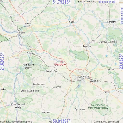
Garbów GPS coordinates[2]
51° 21' 18.612" North, 22° 19' 45.732" East
| Map corner | latitude | longitude |
|---|---|---|
| Upper-left | 51.79216°, | 21.62625° |
| Center: | 51.35517°, | 22.32937° |
| Lower-right: | 50.91397°, | 23.0325° |
| Map W x H: | 97.6×97.6 km | = 60.6×60.6mi |
| max Lat: | 54.83135° ⇑45.9% North |
| Garbów: | 51.35517° |
| min Lat: | ⇓54.1% South 49.21328° |
| min Long | Garbów | max Long |
| 14.20249° | 22.32937° | 24.03723° |
| W 89.4%⇐ | ⇒10.6% E |
Elevation
Elevation of Garbów is 188 m = 617 ft, and this is 3.4 m = 11 ft below average elevation for this country.
| Max E: |
974 m = 3196 ft | 44% |
| Avg. | 191.4 m = 628 ft | |
| Garbów | 188 m = 617 ft | |
Min E: |
-3 m = -10 ft | 56% |
See also: Poland elevation on elevation.city.
Geographical zone
Garbów is located in North temperate zone (between Tropic of Cancer and the Arctic Circle). Distance of this North polar circle is 1691 km =1050.7 mi to North.| Distance of | km | miles | from Garbów |
|---|---|---|---|
| North Pole | 4296.9 | 2670 | to North |
| Arctic Circle | 1691 | 1050.7 | to North |
| Tropic Cancer | 3104.2 | 1928.9 | to South |
| Equator | 5710.2 | 3548.2 | to South |


Nearby cities:
15 places around Garbów: (largest is in red/bold)
• Abramów
11.3 km =7 mi,  355°
355°
• Brzozowa Gać
11.4 km =7.1 mi,  294°
294°
• Jastków
9.3 km =5.8 mi,  127°
127°
• Kamionka
15.9 km =9.9 mi,  35°
35°
• Konopnica
16.8 km =10.4 mi,  147°
147°
• Kozubszczyzna
16.2 km =10.1 mi,  155°
155°
• Kozłówka
15.6 km =9.7 mi,  47°
47°
• Kurów
10.6 km =6.6 mi, 290°
• Markuszów
5.4 km =3.4 mi, 293°
• Michów
19 km =11.8 mi, 356°
• Nałęczów
11.1 km =6.9 mi,  225°
225°
• Ożarów
7.1 km =4.4 mi,  196°
196°
• Przybysławice
3.7 km =2.3 mi,  295°
295°
• Wojciechów
14.5 km =9 mi, 203°
• Wąwolnica
14.4 km =8.9 mi,  242°
242°
Sources, notices
• [Note1] Compared only with cities in Poland existing in our database
• [Src1] Map data: © OpenStreetMap contributors (CC-BY-SA)
• [Src2] Other city data from geonames.org with taken over terms of usage.
• [Src3] Geographical zone / Annual Mean Temperature by Robert A. Rohde @ Wikipedia
