Brzozowa Gać geodata
Brzozowa Gać (Lublin) is a populated place; located in Poland in Europe/Warsaw (GMT+2) time zone. With population of 589 people, there are 3316 cities with bigger population in this country. Compared to other cities in Poland, 54.9% of cities are located further ↓South; 87.1% of cities are located further ←West and 57.8% of cities have higher elevation than Brzozowa Gać. Note1


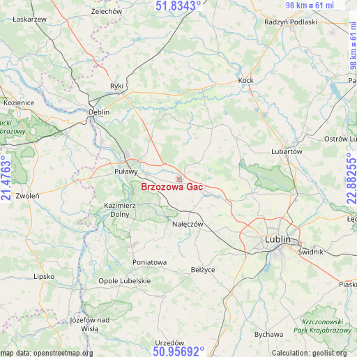
Brzozowa Gać GPS coordinates[2]
51° 23' 51.756" North, 22° 10' 45.912" East
| Map corner | latitude | longitude |
|---|---|---|
| Upper-left | 51.8343°, | 21.4763° |
| Center: | 51.39771°, | 22.17942° |
| Lower-right: | 50.95692°, | 22.88255° |
| Map W x H: | 97.6×97.6 km | = 60.6×60.6mi |
| max Lat: | 54.83135° ⇑45.1% North |
| Brzozowa Gać: | 51.39771° |
| min Lat: | ⇓54.9% South 49.21328° |
| min Long | Brzozowa Gać | max Long |
| 14.20249° | 22.17942° | 24.03723° |
| W 87.1%⇐ | ⇒12.9% E |
Elevation
Elevation of Brzozowa Gać is 151 m = 495 ft, and this is 40.4 m = 133 ft below average elevation for this country.
| Max E: |
974 m = 3196 ft | 57.8% |
| Avg. | 191.4 m = 628 ft | |
| Brzozowa Gać | 151 m = 495 ft | |
Min E: |
-3 m = -10 ft | 42.2% |
See also: Poland elevation on elevation.city.
Geographical zone
Brzozowa Gać is located in North temperate zone (between Tropic of Cancer and the Arctic Circle). Distance of this North polar circle is 1686.3 km =1047.8 mi to North.| Distance of | km | miles | from Brzozowa Gać |
|---|---|---|---|
| North Pole | 4292.2 | 2667 | to North |
| Arctic Circle | 1686.3 | 1047.8 | to North |
| Tropic Cancer | 3109 | 1931.8 | to South |
| Equator | 5714.9 | 3551.1 | to South |


Nearby cities:
15 places around Brzozowa Gać: (largest is in red/bold)
• Abramów
11.5 km =7.1 mi,  55°
55°
• Baranów
18.1 km =11.2 mi,  350°
350°
• Bałtów
14.9 km =9.3 mi,  313°
313°
• Garbów
11.4 km =7.1 mi,  114°
114°
• Kazimierz Dolny
17.9 km =11.1 mi,  240°
240°
• Końskowola
8.9 km =5.5 mi,  278°
278°
• Kurów
1 km =0.6 mi,  152°
152°
• Markuszów
6 km =3.7 mi,  115°
115°
• Michów
17 km =10.6 mi,  33°
33°
• Nałęczów
12.7 km =7.9 mi,  168°
168°
• Ożarów
14.2 km =8.8 mi,  143°
143°
• Przybysławice
7.7 km =4.8 mi, 114°
• Puławy
14.7 km =9.1 mi, 278°
• Wąwolnica
11.7 km =7.3 mi,  191°
191°
• Żyrzyn
12.8 km =8 mi,  331°
331°
Sources, notices
• [Note1] Compared only with cities in Poland existing in our database
• [Src1] Map data: © OpenStreetMap contributors (CC-BY-SA)
• [Src2] Other city data from geonames.org with taken over terms of usage.
• [Src3] Geographical zone / Annual Mean Temperature by Robert A. Rohde @ Wikipedia
