Opole Lubelskie geodata
Opole Lubelskie (Lublin) is a seat of a second-order administrative division; located in Poland in Europe/Warsaw (GMT+2) time zone. With population of 8,780 people, there are 485 cities with bigger population in this country. Compared to other cities in Poland, 50.5% of cities are located further ↑North; 84.5% of cities are located further ←West and 58.4% of cities have higher elevation than Opole Lubelskie. Note1


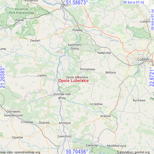
Opole Lubelskie GPS coordinates[2]
51° 8' 51.9" North, 21° 58' 8.292" East
| Map corner | latitude | longitude |
|---|---|---|
| Upper-left | 51.58673°, | 21.26585° |
| Center: | 51.14775°, | 21.96897° |
| Lower-right: | 50.70456°, | 22.6721° |
| Map W x H: | 98.1×98.1 km | = 61×61mi |
| max Lat: | 54.83135° ⇑50.5% North |
| Opole Lubelskie: | 51.14775° |
| min Lat: | ⇓49.5% South 49.21328° |
| min Long | Opole Lubelskie | max Long |
| 14.20249° | 21.96897° | 24.03723° |
| W 84.5%⇐ | ⇒15.5% E |
Elevation
Elevation of Opole Lubelskie is 150 m = 492 ft, and this is 41.4 m = 136 ft below average elevation for this country.
| Max E: |
974 m = 3196 ft | 58.4% |
| Avg. | 191.4 m = 628 ft | |
| Opole Lubelskie | 150 m = 492 ft | |
Min E: |
-3 m = -10 ft | 41.6% |
See also: Poland elevation on elevation.city.
Geographical zone
Opole Lubelskie is located in North temperate zone (between Tropic of Cancer and the Arctic Circle). Distance of this North polar circle is 1714.1 km =1065.1 mi to North.| Distance of | km | miles | from Opole Lubelskie |
|---|---|---|---|
| North Pole | 4320 | 2684.3 | to North |
| Arctic Circle | 1714.1 | 1065.1 | to North |
| Tropic Cancer | 3081.2 | 1914.6 | to South |
| Equator | 5687.1 | 3533.8 | to South |


Nearby cities:
15 places around Opole Lubelskie: (largest is in red/bold)
• Bełżyce
21.9 km =13.6 mi,  82°
82°
• Chodel
12.1 km =7.5 mi,  109°
109°
• Chotcza
16.9 km =10.5 mi,  307°
307°
• Janowiec
20.3 km =12.6 mi,  344°
344°
• Józefów nad Wisłą
15.3 km =9.5 mi,  219°
219°
• Karczmiska
9.1 km =5.7 mi,  5°
5°
• Kazimierz Dolny
19.1 km =11.9 mi,  357°
357°
• Poniatowa
11.8 km =7.3 mi,  72°
72°
• Solec Nad Wisłą
14.2 km =8.8 mi,  264°
264°
• Urzędów
21 km =13 mi,  144°
144°
• Wierzbica
16.8 km =10.4 mi, 144°
• Wilków
14.2 km =8.8 mi,  333°
333°
• Wojciechów
21.6 km =13.4 mi,  63°
63°
• Wąwolnica
20.5 km =12.7 mi,  37°
37°
• Łaziska
6.3 km =3.9 mi, 264°
Sources, notices
• [Note1] Compared only with cities in Poland existing in our database
• [Src1] Map data: © OpenStreetMap contributors (CC-BY-SA)
• [Src2] Other city data from geonames.org with taken over terms of usage.
• [Src3] Geographical zone / Annual Mean Temperature by Robert A. Rohde @ Wikipedia
