Chodel geodata
Chodel (Lublin) is a seat of a third-order administrative division; located in Poland in Europe/Warsaw (GMT+2) time zone. With population of 1,500 people, there are 1837 cities with bigger population in this country. Compared to other cities in Poland, 52.2% of cities are located further ↑North; 86.6% of cities are located further ←West and 52.1% of cities have higher elevation than Chodel. Note1


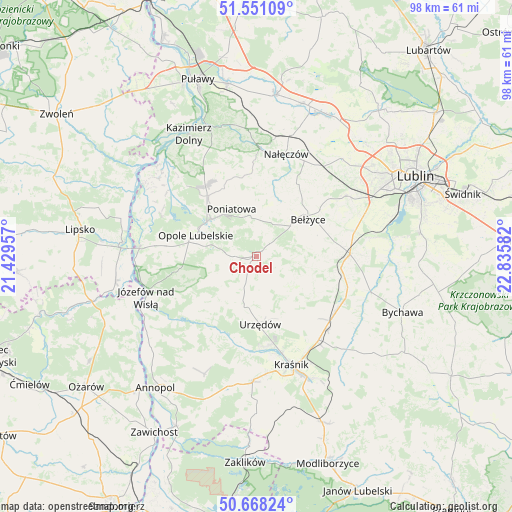
Chodel GPS coordinates[2]
51° 6' 42.372" North, 22° 7' 57.684" East
| Map corner | latitude | longitude |
|---|---|---|
| Upper-left | 51.55109°, | 21.42957° |
| Center: | 51.11177°, | 22.13269° |
| Lower-right: | 50.66824°, | 22.83582° |
| Map W x H: | 98.2×98.2 km | = 61×61mi |
| max Lat: | 54.83135° ⇑52.2% North |
| Chodel: | 51.11177° |
| min Lat: | ⇓47.8% South 49.21328° |
| min Long | Chodel | max Long |
| 14.20249° | 22.13269° | 24.03723° |
| W 86.6%⇐ | ⇒13.4% E |
Elevation
Elevation of Chodel is 166 m = 545 ft, and this is 25.4 m = 83 ft below average elevation for this country.
| Max E: |
974 m = 3196 ft | 52.1% |
| Avg. | 191.4 m = 628 ft | |
| Chodel | 166 m = 545 ft | |
Min E: |
-3 m = -10 ft | 47.9% |
See also: Poland elevation on elevation.city.
Geographical zone
Chodel is located in North temperate zone (between Tropic of Cancer and the Arctic Circle). Distance of this North polar circle is 1718.1 km =1067.6 mi to North.| Distance of | km | miles | from Chodel |
|---|---|---|---|
| North Pole | 4324 | 2686.8 | to North |
| Arctic Circle | 1718.1 | 1067.6 | to North |
| Tropic Cancer | 3077.2 | 1912.1 | to South |
| Equator | 5683.1 | 3531.3 | to South |


Nearby cities:
15 places around Chodel: (largest is in red/bold)
• Bełżyce
12.4 km =7.7 mi,  56°
56°
• Borzechów
10.8 km =6.7 mi,  101°
101°
• Dzierzkowice
17.5 km =10.9 mi,  195°
195°
• Karczmiska
16.8 km =10.4 mi,  321°
321°
• Ludmiłówka
21.2 km =13.2 mi, 199°
• Nałęczów
20.2 km =12.6 mi,  16°
16°
• Niedrzwica Duża
17.9 km =11.1 mi,  88°
88°
• Opole Lubelskie
12.1 km =7.5 mi,  289°
289°
• Poniatowa
7.6 km =4.7 mi,  359°
359°
• Urzędów
13.2 km =8.2 mi,  176°
176°
• Wierzbica
9.8 km =6.1 mi,  189°
189°
• Wilkołaz
18.6 km =11.6 mi,  125°
125°
• Wojciechów
15.8 km =9.8 mi,  29°
29°
• Wąwolnica
20.4 km =12.7 mi,  2°
2°
• Łaziska
18 km =11.2 mi,  280°
280°
Sources, notices
• [Note1] Compared only with cities in Poland existing in our database
• [Src1] Map data: © OpenStreetMap contributors (CC-BY-SA)
• [Src2] Other city data from geonames.org with taken over terms of usage.
• [Src3] Geographical zone / Annual Mean Temperature by Robert A. Rohde @ Wikipedia
