Janowiec geodata
Janowiec (Lublin) is a seat of a third-order administrative division; located in Poland in Europe/Warsaw (GMT+2) time zone. With population of 1,000 people, there are 2459 cities with bigger population in this country. Compared to other cities in Poland, 53.6% of cities are located further ↓South; 83.3% of cities are located further ←West and 68.2% of cities have higher elevation than Janowiec. Note1


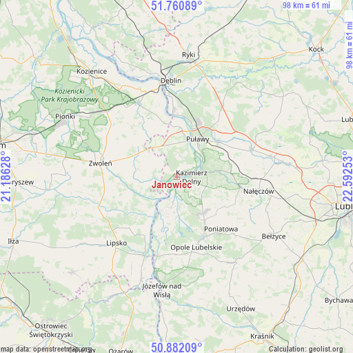
Janowiec GPS coordinates[2]
51° 19' 24.924" North, 21° 53' 21.84" East
| Map corner | latitude | longitude |
|---|---|---|
| Upper-left | 51.76089°, | 21.18628° |
| Center: | 51.32359°, | 21.8894° |
| Lower-right: | 50.88209°, | 22.59253° |
| Map W x H: | 97.7×97.7 km | = 60.7×60.7mi |
| max Lat: | 54.83135° ⇑46.4% North |
| Janowiec: | 51.32359° |
| min Lat: | ⇓53.6% South 49.21328° |
| min Long | Janowiec | max Long |
| 14.20249° | 21.8894° | 24.03723° |
| W 83.3%⇐ | ⇒16.7% E |
Elevation
Elevation of Janowiec is 125 m = 410 ft, and this is 66.4 m = 218 ft below average elevation for this country.
| Max E: |
974 m = 3196 ft | 68.2% |
| Avg. | 191.4 m = 628 ft | |
| Janowiec | 125 m = 410 ft | |
Min E: |
-3 m = -10 ft | 31.8% |
See also: Poland elevation on elevation.city.
Geographical zone
Janowiec is located in North temperate zone (between Tropic of Cancer and the Arctic Circle). Distance of this North polar circle is 1694.5 km =1052.9 mi to North.| Distance of | km | miles | from Janowiec |
|---|---|---|---|
| North Pole | 4300.4 | 2672.1 | to North |
| Arctic Circle | 1694.5 | 1052.9 | to North |
| Tropic Cancer | 3100.7 | 1926.7 | to South |
| Equator | 5706.6 | 3545.9 | to South |


Nearby cities:
15 places around Janowiec: (largest is in red/bold)
• Bałtów
20.7 km =12.9 mi,  26°
26°
• Brzozowa Gać
21.8 km =13.5 mi,  67°
67°
• Chotcza
12.1 km =7.5 mi,  220°
220°
• Gniewoszów
17.6 km =10.9 mi,  342°
342°
• Karczmiska
12.3 km =7.6 mi,  148°
148°
• Kazimierz Dolny
4.6 km =2.9 mi,  96°
96°
• Końskowola
14.8 km =9.2 mi,  49°
49°
• Opole Lubelskie
20.3 km =12.6 mi,  164°
164°
• Przyłęk
10 km =6.2 mi,  260°
260°
• Puławy
11.7 km =7.3 mi, 28°
• Wilków
6.9 km =4.3 mi,  186°
186°
• Wąwolnica
18.2 km =11.3 mi, 100°
• Zwoleń
21.3 km =13.2 mi,  279°
279°
• Łagów
10.8 km =6.7 mi,  296°
296°
• Łaziska
20.2 km =12.6 mi,  182°
182°
Sources, notices
• [Note1] Compared only with cities in Poland existing in our database
• [Src1] Map data: © OpenStreetMap contributors (CC-BY-SA)
• [Src2] Other city data from geonames.org with taken over terms of usage.
• [Src3] Geographical zone / Annual Mean Temperature by Robert A. Rohde @ Wikipedia
