Józefów nad Wisłą geodata
Józefów nad Wisłą (Lublin) is a seat of a third-order administrative division; located in Poland in Europe/Warsaw (GMT+2) time zone. With population of 1,029 people, there are 2421 cities with bigger population in this country. Compared to other cities in Poland, 54.1% of cities are located further ↑North; 82.6% of cities are located further ←West and 59.9% of cities have higher elevation than Józefów nad Wisłą. Note1


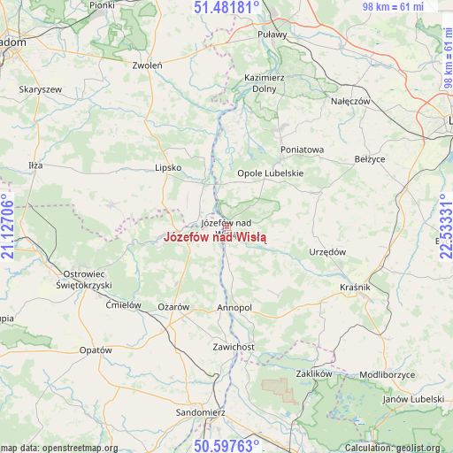
Józefów nad Wisłą GPS coordinates[2]
51° 2' 30.588" North, 21° 49' 48.648" East
| Map corner | latitude | longitude |
|---|---|---|
| Upper-left | 51.48181°, | 21.12706° |
| Center: | 51.04183°, | 21.83018° |
| Lower-right: | 50.59763°, | 22.53331° |
| Map W x H: | 98.3×98.3 km | = 61.1×61.1mi |
| max Lat: | 54.83135° ⇑54.1% North |
| Józefów nad Wisłą: | 51.04183° |
| min Lat: | ⇓45.9% South 49.21328° |
| min Long | Józefów nad W | max Long |
| 14.20249° | 21.83018° | 24.03723° |
| W 82.6%⇐ | ⇒17.4% E |
Elevation
Elevation of Józefów nad Wisłą is 147 m = 482 ft, and this is 44.4 m = 146 ft below average elevation for this country.
| Max E: |
974 m = 3196 ft | 59.9% |
| Avg. | 191.4 m = 628 ft | |
| Józefów nad Wisłą | 147 m = 482 ft | |
Min E: |
-3 m = -10 ft | 40.1% |
See also: Poland elevation on elevation.city.
Geographical zone
Józefów nad Wisłą is located in North temperate zone (between Tropic of Cancer and the Arctic Circle). Distance of this North polar circle is 1725.9 km =1072.4 mi to North.| Distance of | km | miles | from Józefów nad Wisłą |
|---|---|---|---|
| North Pole | 4331.7 | 2691.6 | to North |
| Arctic Circle | 1725.9 | 1072.4 | to North |
| Tropic Cancer | 3069.4 | 1907.2 | to South |
| Equator | 5675.3 | 3526.5 | to South |


Nearby cities:
15 places around Józefów nad Wisłą: (largest is in red/bold)
• Annopol
17.5 km =10.9 mi,  173°
173°
• Bałtów
20.2 km =12.6 mi,  262°
262°
• Chodel
22.5 km =14 mi,  69°
69°
• Chotcza
22.4 km =13.9 mi,  350°
350°
• Dzierzkowice
18.9 km =11.7 mi,  118°
118°
• Księżomierz
18.6 km =11.6 mi,  143°
143°
• Lipsko
18.2 km =11.3 mi,  316°
316°
• Ludmiłówka
18.7 km =11.6 mi,  130°
130°
• Opole Lubelskie
15.3 km =9.5 mi,  39°
39°
• Ożarów
20.6 km =12.8 mi,  213°
213°
• Solec Nad Wisłą
11.4 km =7.1 mi,  336°
336°
• Tarłów
9.2 km =5.7 mi,  241°
241°
• Urzędów
22.5 km =14 mi,  103°
103°
• Wierzbica
19.6 km =12.2 mi, 95°
• Łaziska
11.7 km =7.3 mi,  17°
17°
Sources, notices
• [Note1] Compared only with cities in Poland existing in our database
• [Src1] Map data: © OpenStreetMap contributors (CC-BY-SA)
• [Src2] Other city data from geonames.org with taken over terms of usage.
• [Src3] Geographical zone / Annual Mean Temperature by Robert A. Rohde @ Wikipedia
