Karczmiska geodata
Karczmiska (Lublin) is a seat of a third-order administrative division; located in Poland in Europe/Warsaw (GMT+2) time zone. With population of 800 people, there are 2851 cities with bigger population in this country. Compared to other cities in Poland, 51.6% of cities are located further ↓South; 84.7% of cities are located further ←West and 51.3% of cities have higher elevation than Karczmiska. Note1


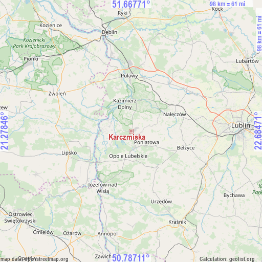
Karczmiska GPS coordinates[2]
51° 13' 46.272" North, 21° 58' 53.688" East
| Map corner | latitude | longitude |
|---|---|---|
| Upper-left | 51.66771°, | 21.27846° |
| Center: | 51.22952°, | 21.98158° |
| Lower-right: | 50.78711°, | 22.68471° |
| Map W x H: | 97.9×97.9 km | = 60.8×60.8mi |
| max Lat: | 54.83135° ⇑48.4% North |
| Karczmiska: | 51.22952° |
| min Lat: | ⇓51.6% South 49.21328° |
| min Long | Karczmiska | max Long |
| 14.20249° | 21.98158° | 24.03723° |
| W 84.7%⇐ | ⇒15.3% E |
Elevation
Elevation of Karczmiska is 169 m = 554 ft, and this is 22.4 m = 73 ft below average elevation for this country.
| Max E: |
974 m = 3196 ft | 51.3% |
| Avg. | 191.4 m = 628 ft | |
| Karczmiska | 169 m = 554 ft | |
Min E: |
-3 m = -10 ft | 48.7% |
See also: Poland elevation on elevation.city.
Geographical zone
Karczmiska is located in North temperate zone (between Tropic of Cancer and the Arctic Circle). Distance of this North polar circle is 1705 km =1059.4 mi to North.| Distance of | km | miles | from Karczmiska |
|---|---|---|---|
| North Pole | 4310.9 | 2678.7 | to North |
| Arctic Circle | 1705 | 1059.4 | to North |
| Tropic Cancer | 3090.3 | 1920.2 | to South |
| Equator | 5696.2 | 3539.5 | to South |


Nearby cities:
15 places around Karczmiska: (largest is in red/bold)
• Chodel
16.8 km =10.4 mi,  141°
141°
• Chotcza
14.3 km =8.9 mi,  274°
274°
• Janowiec
12.3 km =7.6 mi,  328°
328°
• Kazimierz Dolny
10.1 km =6.3 mi,  349°
349°
• Końskowola
20.6 km =12.8 mi,  13°
13°
• Nałęczów
17.4 km =10.8 mi,  68°
68°
• Opole Lubelskie
9.1 km =5.7 mi,  185°
185°
• Poniatowa
11.8 km =7.3 mi,  117°
117°
• Przyłęk
18.5 km =11.5 mi,  298°
298°
• Puławy
20.8 km =12.9 mi,  357°
357°
• Solec Nad Wisłą
18.3 km =11.4 mi,  235°
235°
• Wilków
8.1 km =5 mi, 296°
• Wojciechów
18.4 km =11.4 mi,  87°
87°
• Wąwolnica
13.6 km =8.5 mi,  57°
57°
• Łaziska
12 km =7.5 mi,  216°
216°
Sources, notices
• [Note1] Compared only with cities in Poland existing in our database
• [Src1] Map data: © OpenStreetMap contributors (CC-BY-SA)
• [Src2] Other city data from geonames.org with taken over terms of usage.
• [Src3] Geographical zone / Annual Mean Temperature by Robert A. Rohde @ Wikipedia
