Kazimierz Dolny geodata
Kazimierz Dolny (Lublin) is a seat of a third-order administrative division; located in Poland in Europe/Warsaw (GMT+2) time zone. With population of 3,485 people, there are 918 cities with bigger population in this country. Compared to other cities in Poland, 53.5% of cities are located further ↓South; 84.3% of cities are located further ←West and 65.2% of cities have higher elevation than Kazimierz Dolny. Note1


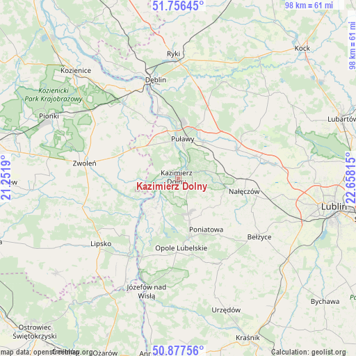
Kazimierz Dolny GPS coordinates[2]
51° 19' 8.796" North, 21° 57' 18.072" East
| Map corner | latitude | longitude |
|---|---|---|
| Upper-left | 51.75645°, | 21.2519° |
| Center: | 51.31911°, | 21.95502° |
| Lower-right: | 50.87756°, | 22.65815° |
| Map W x H: | 97.7×97.7 km | = 60.7×60.7mi |
| max Lat: | 54.83135° ⇑46.5% North |
| Kazimierz Dolny: | 51.31911° |
| min Lat: | ⇓53.5% South 49.21328° |
| min Long | Kazimierz Dolny | max Long |
| 14.20249° | 21.95502° | 24.03723° |
| W 84.3%⇐ | ⇒15.7% E |
Elevation
Elevation of Kazimierz Dolny is 132 m = 433 ft, and this is 59.4 m = 195 ft below average elevation for this country.
| Max E: |
974 m = 3196 ft | 65.2% |
| Avg. | 191.4 m = 628 ft | |
| Kazimierz Dolny | 132 m = 433 ft | |
Min E: |
-3 m = -10 ft | 34.8% |
See also: Poland elevation on elevation.city.
Geographical zone
Kazimierz Dolny is located in North temperate zone (between Tropic of Cancer and the Arctic Circle). Distance of this North polar circle is 1695 km =1053.2 mi to North.| Distance of | km | miles | from Kazimierz Dolny |
|---|---|---|---|
| North Pole | 4300.9 | 2672.5 | to North |
| Arctic Circle | 1695 | 1053.2 | to North |
| Tropic Cancer | 3100.2 | 1926.4 | to South |
| Equator | 5706.2 | 3545.7 | to South |


Nearby cities:
15 places around Kazimierz Dolny: (largest is in red/bold)
• Bałtów
19.6 km =12.2 mi,  14°
14°
• Brzozowa Gać
17.9 km =11.1 mi,  60°
60°
• Chotcza
15.2 km =9.4 mi,  234°
234°
• Janowiec
4.6 km =2.9 mi,  276°
276°
• Karczmiska
10.1 km =6.3 mi,  169°
169°
• Końskowola
12.1 km =7.5 mi,  33°
33°
• Kurów
17.9 km =11.1 mi, 64°
• Nałęczów
18.5 km =11.5 mi,  101°
101°
• Opole Lubelskie
19.1 km =11.9 mi,  177°
177°
• Poniatowa
19.7 km =12.2 mi,  141°
141°
• Przyłęk
14.5 km =9 mi,  265°
265°
• Puławy
10.9 km =6.8 mi, 5°
• Wilków
8.3 km =5.2 mi,  220°
220°
• Wąwolnica
13.6 km =8.5 mi, 101°
• Łagów
15.1 km =9.4 mi,  290°
290°
Sources, notices
• [Note1] Compared only with cities in Poland existing in our database
• [Src1] Map data: © OpenStreetMap contributors (CC-BY-SA)
• [Src2] Other city data from geonames.org with taken over terms of usage.
• [Src3] Geographical zone / Annual Mean Temperature by Robert A. Rohde @ Wikipedia
