Łaziska geodata
Łaziska (Lublin) is a seat of a third-order administrative division; located in Poland in Europe/Warsaw (GMT+2) time zone. With population of 519 people, there are 3490 cities with bigger population in this country. Compared to other cities in Poland, 50.9% of cities are located further ↑North; 83.1% of cities are located further ←West and 64.1% of cities have higher elevation than Łaziska. Note1


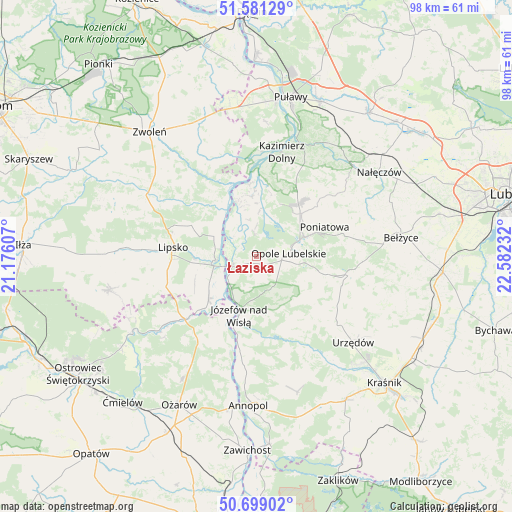
Łaziska GPS coordinates[2]
51° 8' 32.136" North, 21° 52' 45.084" East
| Map corner | latitude | longitude |
|---|---|---|
| Upper-left | 51.58129°, | 21.17607° |
| Center: | 51.14226°, | 21.87919° |
| Lower-right: | 50.69902°, | 22.58232° |
| Map W x H: | 98.1×98.1 km | = 61×61mi |
| max Lat: | 54.83135° ⇑50.9% North |
| Łaziska: | 51.14226° |
| min Lat: | ⇓49.1% South 49.21328° |
| min Long | Łaziska | max Long |
| 14.20249° | 21.87919° | 24.03723° |
| W 83.1%⇐ | ⇒16.9% E |
Elevation
Elevation of Łaziska is 136 m = 446 ft, and this is 55.4 m = 182 ft below average elevation for this country.
| Max E: |
974 m = 3196 ft | 64.1% |
| Avg. | 191.4 m = 628 ft | |
| Łaziska | 136 m = 446 ft | |
Min E: |
-3 m = -10 ft | 35.9% |
See also: Poland elevation on elevation.city.
Geographical zone
Łaziska is located in North temperate zone (between Tropic of Cancer and the Arctic Circle). Distance of this North polar circle is 1714.7 km =1065.5 mi to North.| Distance of | km | miles | from Łaziska |
|---|---|---|---|
| North Pole | 4320.6 | 2684.7 | to North |
| Arctic Circle | 1714.7 | 1065.5 | to North |
| Tropic Cancer | 3080.6 | 1914.2 | to South |
| Equator | 5686.5 | 3533.4 | to South |


Nearby cities:
15 places around Łaziska: (largest is in red/bold)
• Chodel
18 km =11.2 mi,  100°
100°
• Chotcza
13 km =8.1 mi,  326°
326°
• Dzierzkowice
24.1 km =15 mi,  147°
147°
• Janowiec
20.2 km =12.6 mi,  2°
2°
• Józefów nad Wisłą
11.7 km =7.3 mi,  197°
197°
• Karczmiska
12 km =7.5 mi,  36°
36°
• Kazimierz Dolny
20.4 km =12.7 mi,  15°
15°
• Lipsko
16.1 km =10 mi,  276°
276°
• Opole Lubelskie
6.3 km =3.9 mi,  84°
84°
• Poniatowa
18 km =11.2 mi, 76°
• Przyłęk
20.6 km =12.8 mi, 333°
• Solec Nad Wisłą
7.9 km =4.9 mi,  265°
265°
• Tarłów
19.4 km =12.1 mi,  216°
216°
• Wierzbica
20.7 km =12.9 mi,  129°
129°
• Wilków
13.3 km =8.3 mi,  359°
359°
Sources, notices
• [Note1] Compared only with cities in Poland existing in our database
• [Src1] Map data: © OpenStreetMap contributors (CC-BY-SA)
• [Src2] Other city data from geonames.org with taken over terms of usage.
• [Src3] Geographical zone / Annual Mean Temperature by Robert A. Rohde @ Wikipedia
