Kocierzew Południowy geodata
Kocierzew Południowy (Łódź Voivodeship) is a seat of a third-order administrative division; located in Poland in Europe/Warsaw (GMT+2) time zone. With population of 395 people, there are 3593 cities with bigger population in this country. Compared to other cities in Poland, 70.6% of cities are located further ↓South; 58.6% of cities are located further ←West and 81.8% of cities have higher elevation than Kocierzew Południowy. Note1
Administrative division(s):
- Level 1: Łódź Voivodeship
- Level 2: powiat Łowicki
- Level 3: Kocierzew Południowy


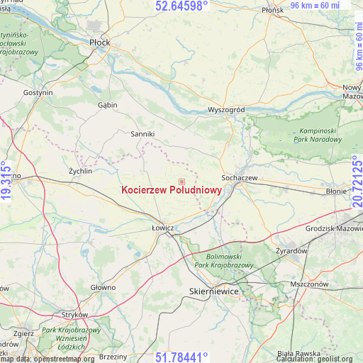
Kocierzew Południowy GPS coordinates[2]
52° 13' 2.208" North, 20° 1' 5.232" East
| Map corner | latitude | longitude |
|---|---|---|
| Upper-left | 52.64598°, | 19.315° |
| Center: | 52.21728°, | 20.01812° |
| Lower-right: | 51.78441°, | 20.72125° |
| Map W x H: | 95.8×95.8 km | = 59.5×59.5mi |
| max Lat: | 54.83135° ⇑29.4% North |
| Kocierzew Południowy: | 52.21728° |
| min Lat: | ⇓70.6% South 49.21328° |
| min Long | Kocierzew Połu | max Long |
| 14.20249° | 20.01812° | 24.03723° |
| W 58.6%⇐ | ⇒41.4% E |
Elevation
Elevation of Kocierzew Południowy is 96 m = 315 ft, and this is 95.4 m = 313 ft below average elevation for this country.
| Max E: |
974 m = 3196 ft | 81.8% |
| Avg. | 191.4 m = 628 ft | |
| Kocierzew Południowy | 96 m = 315 ft | |
Min E: |
-3 m = -10 ft | 18.2% |
See also: Poland elevation on elevation.city.
Geographical zone
Kocierzew Południowy is located in North temperate zone (between Tropic of Cancer and the Arctic Circle). Distance of this North polar circle is 1595.2 km =991.2 mi to North.| Distance of | km | miles | from Kocierzew Południowy |
|---|---|---|---|
| North Pole | 4201 | 2610.4 | to North |
| Arctic Circle | 1595.2 | 991.2 | to North |
| Tropic Cancer | 3200.1 | 1988.4 | to South |
| Equator | 5806 | 3607.7 | to South |


Nearby cities:
15 places around Kocierzew Południowy: (largest is in red/bold)
• Bobrowniki
17 km =10.6 mi,  179°
179°
• Chąśno
5.7 km =3.5 mi,  244°
244°
• Czerwonka-Parcel
16.8 km =10.4 mi,  90°
90°
• Iłów
13.6 km =8.5 mi,  2°
2°
• Kiernozia
11.5 km =7.1 mi,  299°
299°
• Kozłów Biskupi
12.2 km =7.6 mi,  103°
103°
• Młodzieszyn
15.4 km =9.6 mi,  53°
53°
• Nieborów
15.9 km =9.9 mi,  167°
167°
• Nowe Zduny
16.4 km =10.2 mi, 240°
• Rybno
6.4 km =4 mi,  63°
63°
• Sanniki
16.2 km =10.1 mi,  320°
320°
• Sochaczew
15.1 km =9.4 mi,  84°
84°
• Słubice
17.8 km =11.1 mi,  342°
342°
• Zduny
15.3 km =9.5 mi, 243°
• Łowicz
13.2 km =8.2 mi,  202°
202°
Sources, notices
• [Note1] Compared only with cities in Poland existing in our database
• [Src1] Map data: © OpenStreetMap contributors (CC-BY-SA)
• [Src2] Other city data from geonames.org with taken over terms of usage.
• [Src3] Geographical zone / Annual Mean Temperature by Robert A. Rohde @ Wikipedia
