Kozłów Biskupi geodata
Kozłów Biskupi (Mazovia) is a populated place; located in Poland in Europe/Warsaw (GMT+2) time zone. With population of 871 people, there are 2722 cities with bigger population in this country. Compared to other cities in Poland, 69.8% of cities are located further ↓South; 61.1% of cities are located further ←West and 87.2% of cities have higher elevation than Kozłów Biskupi. Note1


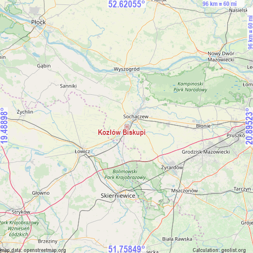
Kozłów Biskupi GPS coordinates[2]
52° 11' 29.796" North, 20° 11' 31.56" East
| Map corner | latitude | longitude |
|---|---|---|
| Upper-left | 52.62055°, | 19.48898° |
| Center: | 52.19161°, | 20.1921° |
| Lower-right: | 51.75849°, | 20.89523° |
| Map W x H: | 95.9×95.9 km | = 59.6×59.6mi |
| max Lat: | 54.83135° ⇑30.2% North |
| Kozłów Biskupi: | 52.19161° |
| min Lat: | ⇓69.8% South 49.21328° |
| min Long | Kozłów Biskup | max Long |
| 14.20249° | 20.1921° | 24.03723° |
| W 61.1%⇐ | ⇒38.9% E |
Elevation
Elevation of Kozłów Biskupi is 84 m = 276 ft, and this is 107.4 m = 352 ft below average elevation for this country.
| Max E: |
974 m = 3196 ft | 87.2% |
| Avg. | 191.4 m = 628 ft | |
| Kozłów Biskupi | 84 m = 276 ft | |
Min E: |
-3 m = -10 ft | 12.8% |
See also: Poland elevation on elevation.city.
Geographical zone
Kozłów Biskupi is located in North temperate zone (between Tropic of Cancer and the Arctic Circle). Distance of this North polar circle is 1598 km =993 mi to North.| Distance of | km | miles | from Kozłów Biskupi |
|---|---|---|---|
| North Pole | 4203.9 | 2612.2 | to North |
| Arctic Circle | 1598 | 993 | to North |
| Tropic Cancer | 3197.2 | 1986.6 | to South |
| Equator | 5803.2 | 3605.9 | to South |


Nearby cities:
15 places around Kozłów Biskupi: (largest is in red/bold)
• Bobrowniki
18.4 km =11.4 mi,  219°
219°
• Bolimów
12.9 km =8 mi,  188°
188°
• Brochów
15 km =9.3 mi,  18°
18°
• Chąśno
17 km =10.6 mi,  271°
271°
• Czerwonka-Parcel
5.6 km =3.5 mi,  61°
61°
• Guzów
12.9 km =8 mi,  130°
130°
• Kocierzew Południowy
12.2 km =7.6 mi,  283°
283°
• Miedniewice
14.2 km =8.8 mi,  148°
148°
• Młodzieszyn
12 km =7.5 mi,  2°
2°
• Nieborów
15.2 km =9.4 mi,  213°
213°
• Paprotnia
15.8 km =9.8 mi,  84°
84°
• Rybno
8.3 km =5.2 mi,  313°
313°
• Sochaczew
5.3 km =3.3 mi,  36°
36°
• Teresin
15.3 km =9.5 mi,  86°
86°
• Wiskitki
17.6 km =10.9 mi, 130°
Sources, notices
• [Note1] Compared only with cities in Poland existing in our database
• [Src1] Map data: © OpenStreetMap contributors (CC-BY-SA)
• [Src2] Other city data from geonames.org with taken over terms of usage.
• [Src3] Geographical zone / Annual Mean Temperature by Robert A. Rohde @ Wikipedia
