Rybno geodata
Rybno (Mazovia) is a seat of a third-order administrative division; located in Poland in Europe/Warsaw (GMT+2) time zone. With population of 607 people, there are 3259 cities with bigger population in this country. Compared to other cities in Poland, 71.1% of cities are located further ↓South; 60% of cities are located further ←West and 86.1% of cities have higher elevation than Rybno. Note1


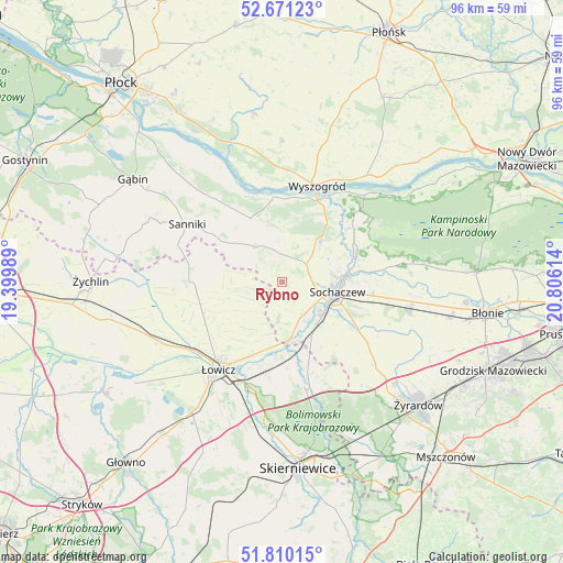
Rybno GPS coordinates[2]
52° 14' 34.008" North, 20° 6' 10.836" East
| Map corner | latitude | longitude |
|---|---|---|
| Upper-left | 52.67123°, | 19.39989° |
| Center: | 52.24278°, | 20.10301° |
| Lower-right: | 51.81015°, | 20.80614° |
| Map W x H: | 95.7×95.7 km | = 59.5×59.5mi |
| max Lat: | 54.83135° ⇑28.9% North |
| Rybno: | 52.24278° |
| min Lat: | ⇓71.1% South 49.21328° |
| min Long | Rybno | max Long |
| 14.20249° | 20.10301° | 24.03723° |
| W 60%⇐ | ⇒40% E |
Elevation
Elevation of Rybno is 87 m = 285 ft, and this is 104.4 m = 343 ft below average elevation for this country.
| Max E: |
974 m = 3196 ft | 86.1% |
| Avg. | 191.4 m = 628 ft | |
| Rybno | 87 m = 285 ft | |
Min E: |
-3 m = -10 ft | 13.9% |
See also: Poland elevation on elevation.city.
Geographical zone
Rybno is located in North temperate zone (between Tropic of Cancer and the Arctic Circle). Distance of this North polar circle is 1592.3 km =989.4 mi to North.| Distance of | km | miles | from Rybno |
|---|---|---|---|
| North Pole | 4198.2 | 2608.6 | to North |
| Arctic Circle | 1592.3 | 989.4 | to North |
| Tropic Cancer | 3202.9 | 1990.2 | to South |
| Equator | 5808.9 | 3609.5 | to South |


Nearby cities:
15 places around Rybno: (largest is in red/bold)
• Bolimów
18.9 km =11.7 mi,  167°
167°
• Brochów
13.8 km =8.6 mi,  51°
51°
• Chąśno
12.1 km =7.5 mi,  244°
244°
• Czerwonka-Parcel
11.4 km =7.1 mi,  105°
105°
• Iłów
11.9 km =7.4 mi,  334°
334°
• Kiernozia
16.1 km =10 mi,  280°
280°
• Kocierzew Południowy
6.4 km =4 mi, 243°
• Kozłów Biskupi
8.3 km =5.2 mi,  133°
133°
• Młodzieszyn
9.1 km =5.7 mi, 46°
• Nieborów
18.5 km =11.5 mi,  187°
187°
• Sanniki
18.7 km =11.6 mi,  301°
301°
• Sochaczew
9.3 km =5.8 mi,  99°
99°
• Słubice
18 km =11.2 mi,  321°
321°
• Wyszogród
17.4 km =10.8 mi,  20°
20°
• Łowicz
18.5 km =11.5 mi,  215°
215°
Sources, notices
• [Note1] Compared only with cities in Poland existing in our database
• [Src1] Map data: © OpenStreetMap contributors (CC-BY-SA)
• [Src2] Other city data from geonames.org with taken over terms of usage.
• [Src3] Geographical zone / Annual Mean Temperature by Robert A. Rohde @ Wikipedia
