Chąśno geodata
Chąśno (Łódź Voivodeship) is a seat of a third-order administrative division; located in Poland in Europe/Warsaw (GMT+2) time zone. With population of 287 people, there are 3627 cities with bigger population in this country. Compared to other cities in Poland, 70% of cities are located further ↓South; 57.5% of cities are located further ←West and 82.2% of cities have higher elevation than Chąśno. Note1


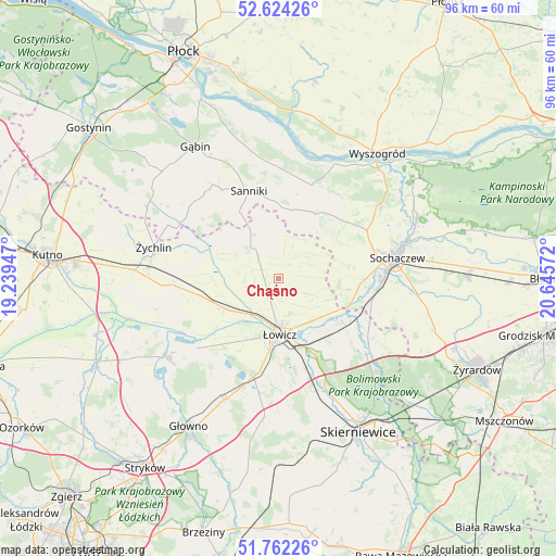
Chąśno GPS coordinates[2]
52° 11' 43.26" North, 19° 56' 33.324" East
| Map corner | latitude | longitude |
|---|---|---|
| Upper-left | 52.62426°, | 19.23947° |
| Center: | 52.19535°, | 19.94259° |
| Lower-right: | 51.76226°, | 20.64572° |
| Map W x H: | 95.8×95.8 km | = 59.5×59.5mi |
| max Lat: | 54.83135° ⇑30% North |
| Chąśno: | 52.19535° |
| min Lat: | ⇓70% South 49.21328° |
| min Long | Chąśno | max Long |
| 14.20249° | 19.94259° | 24.03723° |
| W 57.5%⇐ | ⇒42.5% E |
Elevation
Elevation of Chąśno is 95 m = 312 ft, and this is 96.4 m = 316 ft below average elevation for this country.
| Max E: |
974 m = 3196 ft | 82.2% |
| Avg. | 191.4 m = 628 ft | |
| Chąśno | 95 m = 312 ft | |
Min E: |
-3 m = -10 ft | 17.8% |
See also: Poland elevation on elevation.city.
Geographical zone
Chąśno is located in North temperate zone (between Tropic of Cancer and the Arctic Circle). Distance of this North polar circle is 1597.6 km =992.7 mi to North.| Distance of | km | miles | from Chąśno |
|---|---|---|---|
| North Pole | 4203.5 | 2611.9 | to North |
| Arctic Circle | 1597.6 | 992.7 | to North |
| Tropic Cancer | 3197.7 | 1987 | to South |
| Equator | 5803.6 | 3606.2 | to South |


Nearby cities:
15 places around Chąśno: (largest is in red/bold)
• Bobrowniki
15.5 km =9.6 mi,  160°
160°
• Bolimów
20 km =12.4 mi,  131°
131°
• Iłów
17 km =10.6 mi,  19°
19°
• Kiernozia
9.5 km =5.9 mi,  329°
329°
• Kocierzew Południowy
5.7 km =3.5 mi,  64°
64°
• Kozłów Biskupi
17 km =10.6 mi,  91°
91°
• Nieborów
15.7 km =9.8 mi,  146°
146°
• Nowe Zduny
10.8 km =6.7 mi,  238°
238°
• Pacyna
19.8 km =12.3 mi,  307°
307°
• Rogoźno
19.3 km =12 mi,  207°
207°
• Rybno
12.1 km =7.5 mi, 64°
• Sanniki
15.9 km =9.9 mi,  341°
341°
• Słubice
19.4 km =12.1 mi,  359°
359°
• Zduny
9.7 km =6 mi, 243°
• Łowicz
9.8 km =6.1 mi,  178°
178°
Sources, notices
• [Note1] Compared only with cities in Poland existing in our database
• [Src1] Map data: © OpenStreetMap contributors (CC-BY-SA)
• [Src2] Other city data from geonames.org with taken over terms of usage.
• [Src3] Geographical zone / Annual Mean Temperature by Robert A. Rohde @ Wikipedia
