Ręczno geodata
Ręczno (Łódź Voivodeship) is a seat of a third-order administrative division; located in Poland in Europe/Warsaw (GMT+2) time zone. With population of 690 people, there are 3089 cities with bigger population in this country. Compared to other cities in Poland, 50.7% of cities are located further ↓South; 56.1% of cities are located further ←West and 66.2% of cities have lower elevation than Ręczno. Note1


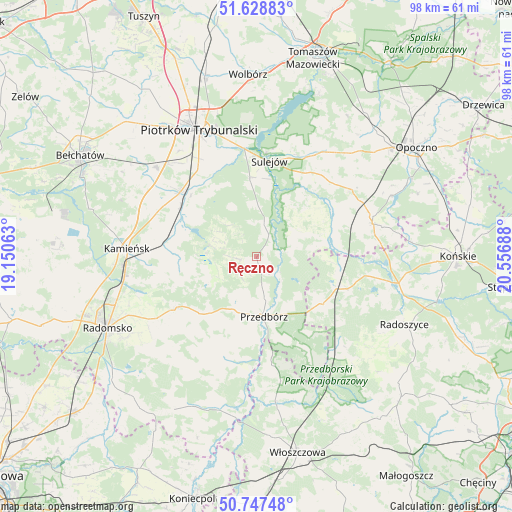
Ręczno GPS coordinates[2]
51° 11' 24.936" North, 19° 51' 13.5" East
| Map corner | latitude | longitude |
|---|---|---|
| Upper-left | 51.62883°, | 19.15063° |
| Center: | 51.19026°, | 19.85375° |
| Lower-right: | 50.74748°, | 20.55688° |
| Map W x H: | 98×98 km | = 60.9×60.9mi |
| max Lat: | 54.83135° ⇑49.3% North |
| Ręczno: | 51.19026° |
| min Lat: | ⇓50.7% South 49.21328° |
| min Long | Ręczno | max Long |
| 14.20249° | 19.85375° | 24.03723° |
| W 56.1%⇐ | ⇒43.9% E |
Elevation
Elevation of Ręczno is 217 m = 712 ft, and this is 25.6 m = 84 ft above average elevation for this country.
| Max E: |
974 m = 3196 ft | 33.8% |
| Ręczno | 217 m 712 ft | |
| Avg. | 191.4 m = 628 ft | |
Min E: |
-3 m = -10 ft | 66.2% |
See also: Poland elevation on elevation.city.
Geographical zone
Ręczno is located in North temperate zone (between Tropic of Cancer and the Arctic Circle). Distance of this North polar circle is 1709.4 km =1062.2 mi to North.| Distance of | km | miles | from Ręczno |
|---|---|---|---|
| North Pole | 4315.2 | 2681.3 | to North |
| Arctic Circle | 1709.4 | 1062.2 | to North |
| Tropic Cancer | 3085.9 | 1917.5 | to South |
| Equator | 5691.8 | 3536.7 | to South |


Nearby cities:
15 places around Ręczno: (largest is in red/bold)
• Aleksandrów
13.1 km =8.1 mi,  46°
46°
• Czermno
15 km =9.3 mi,  126°
126°
• Fałków
18.6 km =11.6 mi,  108°
108°
• Gorzkowice
18.2 km =11.3 mi,  278°
278°
• Kamieńsk
24.9 km =15.5 mi,  273°
273°
• Kobiele Wielkie
23.3 km =14.5 mi,  223°
223°
• Kodrąb
18.7 km =11.6 mi,  237°
237°
• Mniszków
23.8 km =14.8 mi,  32°
32°
• Paradyż
22.2 km =13.8 mi, 54°
• Przedbórz
11.5 km =7.1 mi,  172°
172°
• Rozprza
19.1 km =11.9 mi,  310°
310°
• Sulejów
18.4 km =11.4 mi,  6°
6°
• Wielgomłyny
20.7 km =12.9 mi,  197°
197°
• Łęki Szlacheckie
3.9 km =2.4 mi, 265°
• Żarnów
23.2 km =14.4 mi,  74°
74°
Sources, notices
• [Note1] Compared only with cities in Poland existing in our database
• [Src1] Map data: © OpenStreetMap contributors (CC-BY-SA)
• [Src2] Other city data from geonames.org with taken over terms of usage.
• [Src3] Geographical zone / Annual Mean Temperature by Robert A. Rohde @ Wikipedia
