Aleksandrów geodata
Aleksandrów (Łódź Voivodeship) is a seat of a third-order administrative division; located in Poland in Europe/Warsaw (GMT+2) time zone. With population of 200 people, there are 3643 cities with bigger population in this country. Compared to other cities in Poland, 52.5% of cities are located further ↓South; 58.3% of cities are located further ←West and 62.4% of cities have lower elevation than Aleksandrów. Note1
Administrative division(s):
- Level 1: Łódź Voivodeship
- Level 2: Powiat piotrkowski
- Level 3: Aleksandrów


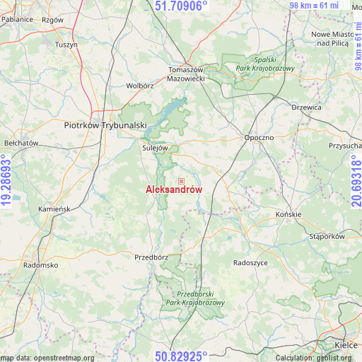
Aleksandrów GPS coordinates[2]
51° 16' 16.536" North, 19° 59' 24.18" East
| Map corner | latitude | longitude |
|---|---|---|
| Upper-left | 51.70906°, | 19.28693° |
| Center: | 51.27126°, | 19.99005° |
| Lower-right: | 50.82925°, | 20.69318° |
| Map W x H: | 97.8×97.8 km | = 60.8×60.8mi |
| max Lat: | 54.83135° ⇑47.5% North |
| Aleksandrów: | 51.27126° |
| min Lat: | ⇓52.5% South 49.21328° |
| min Long | Aleksandrów | max Long |
| 14.20249° | 19.99005° | 24.03723° |
| W 58.3%⇐ | ⇒41.7% E |
Elevation
Elevation of Aleksandrów is 207 m = 679 ft, and this is 15.6 m = 51 ft above average elevation for this country.
| Max E: |
974 m = 3196 ft | 37.6% |
| Aleksandrów | 207 m 679 ft | |
| Avg. | 191.4 m = 628 ft | |
Min E: |
-3 m = -10 ft | 62.4% |
See also: Poland elevation on elevation.city.
Geographical zone
Aleksandrów is located in North temperate zone (between Tropic of Cancer and the Arctic Circle). Distance of this North polar circle is 1700.3 km =1056.5 mi to North.| Distance of | km | miles | from Aleksandrów |
|---|---|---|---|
| North Pole | 4306.2 | 2675.7 | to North |
| Arctic Circle | 1700.3 | 1056.5 | to North |
| Tropic Cancer | 3094.9 | 1923.1 | to South |
| Equator | 5700.8 | 3542.3 | to South |


Nearby cities:
15 places around Aleksandrów: (largest is in red/bold)
• Białaczów
21.6 km =13.4 mi,  82°
82°
• Czermno
18.1 km =11.2 mi,  171°
171°
• Fałków
17.1 km =10.6 mi,  151°
151°
• Mniszków
11.5 km =7.1 mi,  17°
17°
• Opoczno
23.1 km =14.4 mi,  59°
59°
• Paradyż
9.4 km =5.8 mi,  65°
65°
• Piotrków Trybunalski
24.9 km =15.5 mi,  306°
306°
• Przedbórz
21.9 km =13.6 mi,  201°
201°
• Rozprza
24.2 km =15 mi,  278°
278°
• Ruda Maleniecka
21.4 km =13.3 mi,  130°
130°
• Ręczno
13.1 km =8.1 mi,  226°
226°
• Sulejów
11.8 km =7.3 mi,  321°
321°
• Sławno
17.1 km =10.6 mi,  37°
37°
• Łęki Szlacheckie
16.3 km =10.1 mi,  235°
235°
• Żarnów
13.2 km =8.2 mi,  102°
102°
Sources, notices
• [Note1] Compared only with cities in Poland existing in our database
• [Src1] Map data: © OpenStreetMap contributors (CC-BY-SA)
• [Src2] Other city data from geonames.org with taken over terms of usage.
• [Src3] Geographical zone / Annual Mean Temperature by Robert A. Rohde @ Wikipedia
