Żarnów geodata
Żarnów (Łódź Voivodeship) is a seat of a third-order administrative division; located in Poland in Europe/Warsaw (GMT+2) time zone. With population of 870 people, there are 2725 cities with bigger population in this country. Compared to other cities in Poland, 52% of cities are located further ↓South; 60.9% of cities are located further ←West and 72.8% of cities have lower elevation than Żarnów. Note1


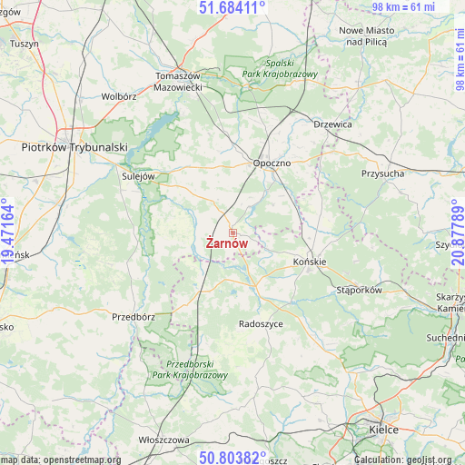
Żarnów GPS coordinates[2]
51° 14' 45.852" North, 20° 10' 29.136" East
| Map corner | latitude | longitude |
|---|---|---|
| Upper-left | 51.68411°, | 19.47164° |
| Center: | 51.24607°, | 20.17476° |
| Lower-right: | 50.80382°, | 20.87789° |
| Map W x H: | 97.9×97.9 km | = 60.8×60.8mi |
| max Lat: | 54.83135° ⇑48% North |
| Żarnów: | 51.24607° |
| min Lat: | ⇓52% South 49.21328° |
| min Long | Żarnów | max Long |
| 14.20249° | 20.17476° | 24.03723° |
| W 60.9%⇐ | ⇒39.1% E |
Elevation
Elevation of Żarnów is 239 m = 784 ft, and this is 47.6 m = 156 ft above average elevation for this country.
| Max E: |
974 m = 3196 ft | 27.2% |
| Żarnów | 239 m 784 ft | |
| Avg. | 191.4 m = 628 ft | |
Min E: |
-3 m = -10 ft | 72.8% |
See also: Poland elevation on elevation.city.
Geographical zone
Żarnów is located in North temperate zone (between Tropic of Cancer and the Arctic Circle). Distance of this North polar circle is 1703.1 km =1058.3 mi to North.| Distance of | km | miles | from Żarnów |
|---|---|---|---|
| North Pole | 4309 | 2677.5 | to North |
| Arctic Circle | 1703.1 | 1058.3 | to North |
| Tropic Cancer | 3092.1 | 1921.3 | to South |
| Equator | 5698 | 3540.6 | to South |


Nearby cities:
15 places around Żarnów: (largest is in red/bold)
• Aleksandrów
13.2 km =8.2 mi,  282°
282°
• Białaczów
10.3 km =6.4 mi,  55°
55°
• Bukowiec Opoczyński
20 km =12.4 mi,  18°
18°
• Czermno
18.3 km =11.4 mi,  214°
214°
• Fałków
13.1 km =8.1 mi,  201°
201°
• Gowarczów
18.7 km =11.6 mi,  78°
78°
• Końskie
17.2 km =10.7 mi,  110°
110°
• Mniszków
16.7 km =10.4 mi,  325°
325°
• Opoczno
16.1 km =10 mi,  26°
26°
• Paradyż
7.9 km =4.9 mi, 327°
• Radoszyce
20 km =12.4 mi,  163°
163°
• Rogów
18.7 km =11.6 mi,  104°
104°
• Ruda Maleniecka
11.6 km =7.2 mi, 162°
• Sławno
16.5 km =10.3 mi,  351°
351°
• Wola Załężna
19.1 km =11.9 mi, 31°
Sources, notices
• [Note1] Compared only with cities in Poland existing in our database
• [Src1] Map data: © OpenStreetMap contributors (CC-BY-SA)
• [Src2] Other city data from geonames.org with taken over terms of usage.
• [Src3] Geographical zone / Annual Mean Temperature by Robert A. Rohde @ Wikipedia
