Paradyż geodata
Paradyż (Łódź Voivodeship) is a seat of a third-order administrative division; located in Poland in Europe/Warsaw (GMT+2) time zone. With population of 530 people, there are 3452 cities with bigger population in this country. Compared to other cities in Poland, 53.3% of cities are located further ↓South; 60.2% of cities are located further ←West and 57.7% of cities have lower elevation than Paradyż. Note1


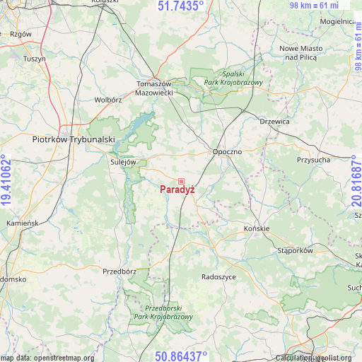
Paradyż GPS coordinates[2]
51° 18' 21.744" North, 20° 6' 49.464" East
| Map corner | latitude | longitude |
|---|---|---|
| Upper-left | 51.7435°, | 19.41062° |
| Center: | 51.30604°, | 20.11374° |
| Lower-right: | 50.86437°, | 20.81687° |
| Map W x H: | 97.8×97.7 km | = 60.8×60.7mi |
| max Lat: | 54.83135° ⇑46.7% North |
| Paradyż: | 51.30604° |
| min Lat: | ⇓53.3% South 49.21328° |
| min Long | Paradyż | max Long |
| 14.20249° | 20.11374° | 24.03723° |
| W 60.2%⇐ | ⇒39.8% E |
Elevation
Elevation of Paradyż is 193 m = 633 ft, and this is 1.6 m = 5 ft above average elevation for this country.
| Max E: |
974 m = 3196 ft | 42.3% |
| Paradyż | 193 m 633 ft | |
| Avg. | 191.4 m = 628 ft | |
Min E: |
-3 m = -10 ft | 57.7% |
See also: Poland elevation on elevation.city.
Geographical zone
Paradyż is located in North temperate zone (between Tropic of Cancer and the Arctic Circle). Distance of this North polar circle is 1696.5 km =1054.2 mi to North.| Distance of | km | miles | from Paradyż |
|---|---|---|---|
| North Pole | 4302.4 | 2673.4 | to North |
| Arctic Circle | 1696.5 | 1054.2 | to North |
| Tropic Cancer | 3098.8 | 1925.5 | to South |
| Equator | 5704.7 | 3544.7 | to South |


Nearby cities:
15 places around Paradyż: (largest is in red/bold)
• Aleksandrów
9.4 km =5.8 mi,  245°
245°
• Białaczów
12.8 km =8 mi,  93°
93°
• Bukowiec Opoczyński
16.2 km =10.1 mi,  40°
40°
• Czermno
22.6 km =14 mi,  195°
195°
• Fałków
18.9 km =11.7 mi,  181°
181°
• Gowarczów
22.8 km =14.2 mi,  97°
97°
• Mniszków
8.8 km =5.5 mi,  323°
323°
• Mroczków Gościnny
20.9 km =13 mi,  66°
66°
• Opoczno
13.8 km =8.6 mi,  55°
55°
• Ruda Maleniecka
19.4 km =12.1 mi,  156°
156°
• Ręczno
22.2 km =13.8 mi,  234°
234°
• Sulejów
16.8 km =10.4 mi,  288°
288°
• Sławno
9.8 km =6.1 mi,  10°
10°
• Wola Załężna
17.1 km =10.6 mi, 55°
• Żarnów
7.9 km =4.9 mi,  147°
147°
Sources, notices
• [Note1] Compared only with cities in Poland existing in our database
• [Src1] Map data: © OpenStreetMap contributors (CC-BY-SA)
• [Src2] Other city data from geonames.org with taken over terms of usage.
• [Src3] Geographical zone / Annual Mean Temperature by Robert A. Rohde @ Wikipedia
