Mroczków Gościnny geodata
Mroczków Gościnny (Łódź Voivodeship) is a populated place; located in Poland in Europe/Warsaw (GMT+2) time zone. With population of 800 people, there are 2851 cities with bigger population in this country. Compared to other cities in Poland, 54.6% of cities are located further ↓South; 63.6% of cities are located further ←West and 67.4% of cities have lower elevation than Mroczków Gościnny. Note1


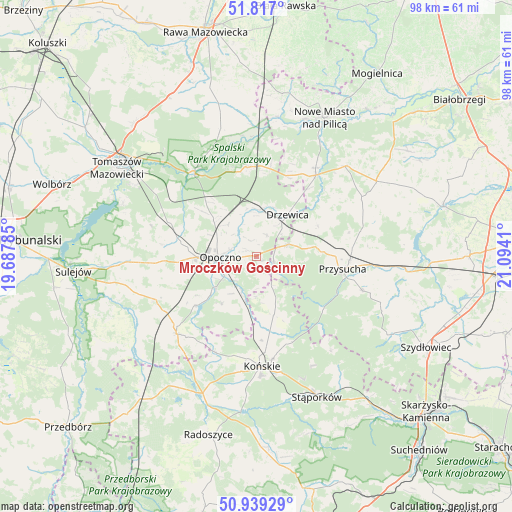
Mroczków Gościnny GPS coordinates[2]
51° 22' 48.9" North, 20° 23' 27.492" East
| Map corner | latitude | longitude |
|---|---|---|
| Upper-left | 51.817°, | 19.68785° |
| Center: | 51.38025°, | 20.39097° |
| Lower-right: | 50.93929°, | 21.0941° |
| Map W x H: | 97.6×97.6 km | = 60.6×60.6mi |
| max Lat: | 54.83135° ⇑45.4% North |
| Mroczków Gościnny: | 51.38025° |
| min Lat: | ⇓54.6% South 49.21328° |
| min Long | Mroczków Gośc | max Long |
| 14.20249° | 20.39097° | 24.03723° |
| W 63.6%⇐ | ⇒36.4% E |
Elevation
Elevation of Mroczków Gościnny is 221 m = 725 ft, and this is 29.6 m = 97 ft above average elevation for this country.
| Max E: |
974 m = 3196 ft | 32.6% |
| Mroczków Gościnny | 221 m 725 ft | |
| Avg. | 191.4 m = 628 ft | |
Min E: |
-3 m = -10 ft | 67.4% |
See also: Poland elevation on elevation.city.
Geographical zone
Mroczków Gościnny is located in North temperate zone (between Tropic of Cancer and the Arctic Circle). Distance of this North polar circle is 1688.2 km =1049 mi to North.| Distance of | km | miles | from Mroczków Gościnny |
|---|---|---|---|
| North Pole | 4294.1 | 2668.2 | to North |
| Arctic Circle | 1688.2 | 1049 | to North |
| Tropic Cancer | 3107 | 1930.6 | to South |
| Equator | 5712.9 | 3549.8 | to South |


Nearby cities:
15 places around Mroczków Gościnny: (largest is in red/bold)
• Białaczów
11.2 km =7 mi,  215°
215°
• Bukowiec Opoczyński
9.6 km =6 mi,  295°
295°
• Drzewica
9.9 km =6.2 mi,  37°
37°
• Gielniów
6.7 km =4.2 mi,  69°
69°
• Gowarczów
11.8 km =7.3 mi,  163°
163°
• Inowłódz
20.1 km =12.5 mi,  324°
324°
• Odrzywół
19.2 km =11.9 mi, 36°
• Opoczno
7.8 km =4.8 mi,  266°
266°
• Paradyż
20.9 km =13 mi,  246°
246°
• Poświętne
17 km =10.6 mi,  353°
353°
• Przysucha
16.7 km =10.4 mi,  98°
98°
• Rogów
19.8 km =12.3 mi,  171°
171°
• Rusinów
15 km =9.3 mi, 65°
• Sławno
17.4 km =10.8 mi, 274°
• Wola Załężna
5.3 km =3.3 mi,  285°
285°
Sources, notices
• [Note1] Compared only with cities in Poland existing in our database
• [Src1] Map data: © OpenStreetMap contributors (CC-BY-SA)
• [Src2] Other city data from geonames.org with taken over terms of usage.
• [Src3] Geographical zone / Annual Mean Temperature by Robert A. Rohde @ Wikipedia
