Białaczów geodata
Białaczów (Łódź Voivodeship) is a seat of a third-order administrative division; located in Poland in Europe/Warsaw (GMT+2) time zone. With population of 1,500 people, there are 1837 cities with bigger population in this country. Compared to other cities in Poland, 53.1% of cities are located further ↓South; 62.5% of cities are located further ←West and 62.4% of cities have lower elevation than Białaczów. Note1


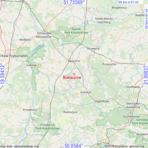
Białaczów GPS coordinates[2]
51° 17' 53.34" North, 20° 17' 50.064" East
| Map corner | latitude | longitude |
|---|---|---|
| Upper-left | 51.73569°, | 19.59412° |
| Center: | 51.29815°, | 20.29724° |
| Lower-right: | 50.8564°, | 21.00037° |
| Map W x H: | 97.8×97.8 km | = 60.8×60.8mi |
| max Lat: | 54.83135° ⇑46.9% North |
| Białaczów: | 51.29815° |
| min Lat: | ⇓53.1% South 49.21328° |
| min Long | Białaczów | max Long |
| 14.20249° | 20.29724° | 24.03723° |
| W 62.5%⇐ | ⇒37.5% E |
Elevation
Elevation of Białaczów is 207 m = 679 ft, and this is 15.6 m = 51 ft above average elevation for this country.
| Max E: |
974 m = 3196 ft | 37.6% |
| Białaczów | 207 m 679 ft | |
| Avg. | 191.4 m = 628 ft | |
Min E: |
-3 m = -10 ft | 62.4% |
See also: Poland elevation on elevation.city.
Geographical zone
Białaczów is located in North temperate zone (between Tropic of Cancer and the Arctic Circle). Distance of this North polar circle is 1697.4 km =1054.7 mi to North.| Distance of | km | miles | from Białaczów |
|---|---|---|---|
| North Pole | 4303.2 | 2673.9 | to North |
| Arctic Circle | 1697.4 | 1054.7 | to North |
| Tropic Cancer | 3097.9 | 1924.9 | to South |
| Equator | 5703.8 | 3544.2 | to South |


Nearby cities:
15 places around Białaczów: (largest is in red/bold)
• Aleksandrów
21.6 km =13.4 mi,  262°
262°
• Bukowiec Opoczyński
13.4 km =8.3 mi,  350°
350°
• Drzewica
21.1 km =13.1 mi,  36°
36°
• Gielniów
17.1 km =10.6 mi,  48°
48°
• Gowarczów
10.1 km =6.3 mi,  102°
102°
• Końskie
14.1 km =8.8 mi,  147°
147°
• Mniszków
19.6 km =12.2 mi,  294°
294°
• Mroczków Gościnny
11.2 km =7 mi, 35°
• Opoczno
8.7 km =5.4 mi, 351°
• Paradyż
12.8 km =8 mi,  273°
273°
• Rogów
14.2 km =8.8 mi,  137°
137°
• Ruda Maleniecka
17.7 km =11 mi,  196°
196°
• Sławno
15.1 km =9.4 mi,  313°
313°
• Wola Załężna
10.6 km =6.6 mi,  7°
7°
• Żarnów
10.3 km =6.4 mi,  235°
235°
Sources, notices
• [Note1] Compared only with cities in Poland existing in our database
• [Src1] Map data: © OpenStreetMap contributors (CC-BY-SA)
• [Src2] Other city data from geonames.org with taken over terms of usage.
• [Src3] Geographical zone / Annual Mean Temperature by Robert A. Rohde @ Wikipedia
