Biszcza geodata
Biszcza (Lublin) is a seat of a third-order administrative division; located in Poland in Europe/Warsaw (GMT+2) time zone. With population of 1,901 people, there are 1551 cities with bigger population in this country. Compared to other cities in Poland, 69.4% of cities are located further ↑North; 93.3% of cities are located further ←West and 60.3% of cities have lower elevation than Biszcza. Note1


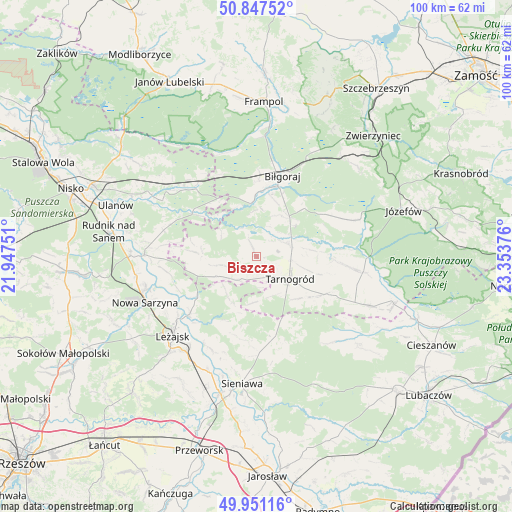
Biszcza GPS coordinates[2]
50° 24' 5.256" North, 22° 39' 2.268" East
| Map corner | latitude | longitude |
|---|---|---|
| Upper-left | 50.84752°, | 21.94751° |
| Center: | 50.40146°, | 22.65063° |
| Lower-right: | 49.95116°, | 23.35376° |
| Map W x H: | 99.7×99.7 km | = 62×62mi |
| max Lat: | 54.83135° ⇑69.4% North |
| Biszcza: | 50.40146° |
| min Lat: | ⇓30.6% South 49.21328° |
| min Long | Biszcza | max Long |
| 14.20249° | 22.65063° | 24.03723° |
| W 93.3%⇐ | ⇒6.7% E |
Elevation
Elevation of Biszcza is 201 m = 659 ft, and this is 9.6 m = 31 ft above average elevation for this country.
| Max E: |
974 m = 3196 ft | 39.7% |
| Biszcza | 201 m 659 ft | |
| Avg. | 191.4 m = 628 ft | |
Min E: |
-3 m = -10 ft | 60.3% |
See also: Poland elevation on elevation.city.
Geographical zone
Biszcza is located in North temperate zone (between Tropic of Cancer and the Arctic Circle). Distance of this North polar circle is 1797.1 km =1116.7 mi to North.| Distance of | km | miles | from Biszcza |
|---|---|---|---|
| North Pole | 4402.9 | 2735.8 | to North |
| Arctic Circle | 1797.1 | 1116.7 | to North |
| Tropic Cancer | 2998.2 | 1863 | to South |
| Equator | 5604.1 | 3482.2 | to South |


Nearby cities:
15 places around Biszcza: (largest is in red/bold)
• Adamówka
16.2 km =10.1 mi,  168°
168°
• Aleksandrów
18.6 km =11.6 mi,  67°
67°
• Babice
18.6 km =11.6 mi,  107°
107°
• Biłgoraj
16.3 km =10.1 mi,  18°
18°
• Bystre
18.2 km =11.3 mi,  262°
262°
• Harasiuki
15 km =9.3 mi,  303°
303°
• Księżpol
6.5 km =4 mi, 68°
• Kuryłówka
17.3 km =10.7 mi,  229°
229°
• Piskorowice
20.4 km =12.7 mi,  205°
205°
• Potok Górny
6.6 km =4.1 mi,  253°
253°
• Przychojec
21.1 km =13.1 mi,  237°
237°
• Stare Miasto
20.1 km =12.5 mi, 231°
• Tarnogród
7.9 km =4.9 mi,  124°
124°
• Łukowa
21 km =13 mi,  98°
98°
• Łukowa
21.6 km =13.4 mi, 246°
Sources, notices
• [Note1] Compared only with cities in Poland existing in our database
• [Src1] Map data: © OpenStreetMap contributors (CC-BY-SA)
• [Src2] Other city data from geonames.org with taken over terms of usage.
• [Src3] Geographical zone / Annual Mean Temperature by Robert A. Rohde @ Wikipedia
