Adamówka geodata
Adamówka (Subcarpathian) is a seat of a third-order administrative division; located in Poland in Europe/Warsaw (GMT+2) time zone. With population of 1,205 people, there are 2162 cities with bigger population in this country. Compared to other cities in Poland, 73% of cities are located further ↑North; 93.8% of cities are located further ←West and 63.8% of cities have lower elevation than Adamówka. Note1


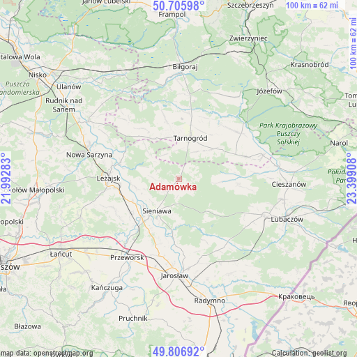
Adamówka GPS coordinates[2]
50° 15' 30.852" North, 22° 41' 45.42" East
| Map corner | latitude | longitude |
|---|---|---|
| Upper-left | 50.70598°, | 21.99283° |
| Center: | 50.25857°, | 22.69595° |
| Lower-right: | 49.80692°, | 23.39908° |
| Map W x H: | 100×100 km | = 62.1×62.1mi |
| max Lat: | 54.83135° ⇑73% North |
| Adamówka: | 50.25857° |
| min Lat: | ⇓27% South 49.21328° |
| min Long | Adamówka | max Long |
| 14.20249° | 22.69595° | 24.03723° |
| W 93.8%⇐ | ⇒6.2% E |
Elevation
Elevation of Adamówka is 211 m = 692 ft, and this is 19.6 m = 64 ft above average elevation for this country.
| Max E: |
974 m = 3196 ft | 36.2% |
| Adamówka | 211 m 692 ft | |
| Avg. | 191.4 m = 628 ft | |
Min E: |
-3 m = -10 ft | 63.8% |
See also: Poland elevation on elevation.city.
Geographical zone
Adamówka is located in North temperate zone (between Tropic of Cancer and the Arctic Circle). Distance of this North polar circle is 1812.9 km =1126.5 mi to North.| Distance of | km | miles | from Adamówka |
|---|---|---|---|
| North Pole | 4418.8 | 2745.7 | to North |
| Arctic Circle | 1812.9 | 1126.5 | to North |
| Tropic Cancer | 2982.3 | 1853.1 | to South |
| Equator | 5588.2 | 3472.3 | to South |


Nearby cities:
15 places around Adamówka: (largest is in red/bold)
• Babice
18 km =11.2 mi,  54°
54°
• Biszcza
16.2 km =10.1 mi,  348°
348°
• Dzików Stary
16.7 km =10.4 mi,  94°
94°
• Dębno
14.3 km =8.9 mi,  241°
241°
• Gorzyce
16.7 km =10.4 mi,  209°
209°
• Kuryłówka
17 km =10.6 mi,  285°
285°
• Leżachów
13.7 km =8.5 mi,  203°
203°
• Piskorowice
12.2 km =7.6 mi,  257°
257°
• Potok Górny
17 km =10.6 mi,  325°
325°
• Sieniawa
10.9 km =6.8 mi, 214°
• Tarnogród
11.8 km =7.3 mi,  15°
15°
• Tryńcza
15 km =9.3 mi,  223°
223°
• Ubieszyn
13.3 km =8.3 mi, 218°
• Wierzawice
17.6 km =10.9 mi, 261°
• Wylewa
9.1 km =5.7 mi, 214°
Sources, notices
• [Note1] Compared only with cities in Poland existing in our database
• [Src1] Map data: © OpenStreetMap contributors (CC-BY-SA)
• [Src2] Other city data from geonames.org with taken over terms of usage.
• [Src3] Geographical zone / Annual Mean Temperature by Robert A. Rohde @ Wikipedia
