Bojanów geodata
Bojanów (Subcarpathian) is a seat of a third-order administrative division; located in Poland in Europe/Warsaw (GMT+2) time zone. With population of 1,200 people, there are 2164 cities with bigger population in this country. Compared to other cities in Poland, 69% of cities are located further ↑North; 84.2% of cities are located further ←West and 51.5% of cities have lower elevation than Bojanów. Note1


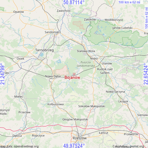
Bojanów GPS coordinates[2]
50° 25' 31.116" North, 21° 57' 3.996" East
| Map corner | latitude | longitude |
|---|---|---|
| Upper-left | 50.87114°, | 21.24799° |
| Center: | 50.42531°, | 21.95111° |
| Lower-right: | 49.97524°, | 22.65424° |
| Map W x H: | 99.6×99.6 km | = 61.9×61.9mi |
| max Lat: | 54.83135° ⇑69% North |
| Bojanów: | 50.42531° |
| min Lat: | ⇓31% South 49.21328° |
| min Long | Bojanów | max Long |
| 14.20249° | 21.95111° | 24.03723° |
| W 84.2%⇐ | ⇒15.8% E |
Elevation
Elevation of Bojanów is 176 m = 577 ft, and this is 15.4 m = 51 ft below average elevation for this country.
| Max E: |
974 m = 3196 ft | 48.5% |
| Avg. | 191.4 m = 628 ft | |
| Bojanów | 176 m = 577 ft | |
Min E: |
-3 m = -10 ft | 51.5% |
See also: Poland elevation on elevation.city.
Geographical zone
Bojanów is located in North temperate zone (between Tropic of Cancer and the Arctic Circle). Distance of this North polar circle is 1794.4 km =1115 mi to North.| Distance of | km | miles | from Bojanów |
|---|---|---|---|
| North Pole | 4400.3 | 2734.2 | to North |
| Arctic Circle | 1794.4 | 1115 | to North |
| Tropic Cancer | 3000.8 | 1864.6 | to South |
| Equator | 5606.8 | 3483.9 | to South |


Nearby cities:
15 places around Bojanów: (largest is in red/bold)
• Cholewiana Góra
12.1 km =7.5 mi,  133°
133°
• Dzikowiec
18.6 km =11.6 mi,  204°
204°
• Grębów
16.5 km =10.3 mi,  340°
340°
• Gwoździec
6.2 km =3.9 mi,  152°
152°
• Jeżowe
13.7 km =8.5 mi,  114°
114°
• Kamień
16.1 km =10 mi, 125°
• Kończyce
14.4 km =8.9 mi,  89°
89°
• Lipnica
15.8 km =9.8 mi, 196°
• Majdan Królewski
15.4 km =9.6 mi,  250°
250°
• Mechowiec
18.4 km =11.4 mi,  212°
212°
• Nisko
17 km =10.6 mi,  51°
51°
• Nowa Dęba
14.2 km =8.8 mi,  271°
271°
• Racławice
18.1 km =11.2 mi,  57°
57°
• Raniżów
18.6 km =11.6 mi,  175°
175°
• Stalowa Wola
19 km =11.8 mi,  22°
22°
Sources, notices
• [Note1] Compared only with cities in Poland existing in our database
• [Src1] Map data: © OpenStreetMap contributors (CC-BY-SA)
• [Src2] Other city data from geonames.org with taken over terms of usage.
• [Src3] Geographical zone / Annual Mean Temperature by Robert A. Rohde @ Wikipedia
