Gwoździec geodata
Gwoździec (Subcarpathian) is a populated place; located in Poland in Europe/Warsaw (GMT+2) time zone. With population of 618 people, there are 3234 cities with bigger population in this country. Compared to other cities in Poland, 70.1% of cities are located further ↑North; 84.8% of cities are located further ←West and 57.7% of cities have lower elevation than Gwoździec. Note1


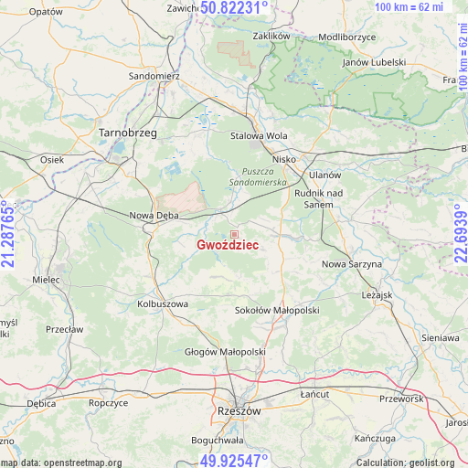
Gwoździec GPS coordinates[2]
50° 22' 33.636" North, 21° 59' 26.772" East
| Map corner | latitude | longitude |
|---|---|---|
| Upper-left | 50.82231°, | 21.28765° |
| Center: | 50.37601°, | 21.99077° |
| Lower-right: | 49.92547°, | 22.6939° |
| Map W x H: | 99.7×99.7 km | = 62×62mi |
| max Lat: | 54.83135° ⇑70.1% North |
| Gwoździec: | 50.37601° |
| min Lat: | ⇓29.9% South 49.21328° |
| min Long | Gwoździec | max Long |
| 14.20249° | 21.99077° | 24.03723° |
| W 84.8%⇐ | ⇒15.2% E |
Elevation
Elevation of Gwoździec is 193 m = 633 ft, and this is 1.6 m = 5 ft above average elevation for this country.
| Max E: |
974 m = 3196 ft | 42.3% |
| Gwoździec | 193 m 633 ft | |
| Avg. | 191.4 m = 628 ft | |
Min E: |
-3 m = -10 ft | 57.7% |
See also: Poland elevation on elevation.city.
Geographical zone
Gwoździec is located in North temperate zone (between Tropic of Cancer and the Arctic Circle). Distance of this North polar circle is 1799.9 km =1118.4 mi to North.| Distance of | km | miles | from Gwoździec |
|---|---|---|---|
| North Pole | 4405.8 | 2737.6 | to North |
| Arctic Circle | 1799.9 | 1118.4 | to North |
| Tropic Cancer | 2995.4 | 1861.3 | to South |
| Equator | 5601.3 | 3480.5 | to South |


Nearby cities:
15 places around Gwoździec: (largest is in red/bold)
• Bojanów
6.2 km =3.9 mi,  332°
332°
• Cholewiana Góra
6.6 km =4.1 mi,  115°
115°
• Dzikowiec
15.5 km =9.6 mi,  222°
222°
• Górno
15.1 km =9.4 mi,  133°
133°
• Jeżowe
9.7 km =6 mi,  90°
90°
• Kamień
11 km =6.8 mi,  110°
110°
• Kończyce
12.8 km =8 mi,  64°
64°
• Lipnica
12.1 km =7.5 mi, 217°
• Majdan Królewski
17.3 km =10.7 mi,  271°
271°
• Mechowiec
16.2 km =10.1 mi,  231°
231°
• Nowa Dęba
18 km =11.2 mi,  289°
289°
• Raniżów
13.1 km =8.1 mi,  186°
186°
• Sokołów Małopolski
18.7 km =11.6 mi,  150°
150°
• Wólka Łętowska
16.4 km =10.2 mi, 110°
• Łętownia
18.2 km =11.3 mi, 108°
Sources, notices
• [Note1] Compared only with cities in Poland existing in our database
• [Src1] Map data: © OpenStreetMap contributors (CC-BY-SA)
• [Src2] Other city data from geonames.org with taken over terms of usage.
• [Src3] Geographical zone / Annual Mean Temperature by Robert A. Rohde @ Wikipedia
