Raciechowice geodata
Raciechowice (Lesser Poland) is a populated place; located in Poland in Europe/Warsaw (GMT+2) time zone. With population of 870 people, there are 2725 cities with bigger population in this country. Compared to other cities in Poland, 90% of cities are located further ↑North; 60.7% of cities are located further ←West and 89.9% of cities have lower elevation than Raciechowice. Note1


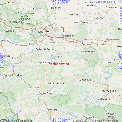
Raciechowice GPS coordinates[2]
49° 50' 40.056" North, 20° 8' 34.512" East
| Map corner | latitude | longitude |
|---|---|---|
| Upper-left | 50.29576°, | 19.4398° |
| Center: | 49.84446°, | 20.14292° |
| Lower-right: | 49.38891°, | 20.84605° |
| Map W x H: | 100.8×100.8 km | = 62.6×62.6mi |
| max Lat: | 54.83135° ⇑90% North |
| Raciechowice: | 49.84446° |
| min Lat: | ⇓10% South 49.21328° |
| min Long | Raciechowice | max Long |
| 14.20249° | 20.14292° | 24.03723° |
| W 60.7%⇐ | ⇒39.3% E |
Elevation
Elevation of Raciechowice is 327 m = 1073 ft, and this is 135.6 m = 445 ft above average elevation for this country.
| Max E: |
974 m = 3196 ft | 10.1% |
| Raciechowice | 327 m 1073 ft | |
| Avg. | 191.4 m = 628 ft | |
Min E: |
-3 m = -10 ft | 89.9% |
See also: Poland elevation on elevation.city.
Geographical zone
Raciechowice is located in North temperate zone (between Tropic of Cancer and the Arctic Circle). Distance of this North polar circle is 1859 km =1155.1 mi to North.| Distance of | km | miles | from Raciechowice |
|---|---|---|---|
| North Pole | 4464.9 | 2774.4 | to North |
| Arctic Circle | 1859 | 1155.1 | to North |
| Tropic Cancer | 2936.3 | 1824.5 | to South |
| Equator | 5542.2 | 3443.8 | to South |


Nearby cities:
15 places around Raciechowice: (largest is in red/bold)
• Brzezowa
6.4 km =4 mi,  282°
282°
• Brzączowice
8.3 km =5.2 mi,  293°
293°
• Dobczyce
5.6 km =3.5 mi,  316°
316°
• Gdów
8.1 km =5 mi,  29°
29°
• Jodłownik
10.2 km =6.3 mi,  138°
138°
• Kornatka
4.2 km =2.6 mi, 279°
• Krasne-Lasocice
7.1 km =4.4 mi,  119°
119°
• Lipnik
7.5 km =4.7 mi,  214°
214°
• Marszowice
10.5 km =6.5 mi,  39°
39°
• Poręba
10.5 km =6.5 mi,  239°
239°
• Trzemeśnia
8.9 km =5.5 mi,  257°
257°
• Wiśniowa
6.6 km =4.1 mi,  197°
197°
• Zasań
7.3 km =4.5 mi,  248°
248°
• Zręczyce
7.2 km =4.5 mi,  48°
48°
• Łęki
9.1 km =5.7 mi, 263°
Sources, notices
• [Note1] Compared only with cities in Poland existing in our database
• [Src1] Map data: © OpenStreetMap contributors (CC-BY-SA)
• [Src2] Other city data from geonames.org with taken over terms of usage.
• [Src3] Geographical zone / Annual Mean Temperature by Robert A. Rohde @ Wikipedia
