Rudnik Pierwszy geodata
Rudnik Pierwszy (Lublin) is a populated place; located in Poland in Europe/Warsaw (GMT+2) time zone. With population of 827 people, there are 2809 cities with bigger population in this country. Compared to other cities in Poland, 56.1% of cities are located further ↑North; 90.8% of cities are located further ←West and 68.1% of cities have lower elevation than Rudnik Pierwszy. Note1


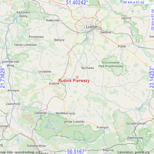
Rudnik Pierwszy GPS coordinates[2]
50° 57' 42.012" North, 22° 26' 21.84" East
| Map corner | latitude | longitude |
|---|---|---|
| Upper-left | 51.40242°, | 21.73628° |
| Center: | 50.96167°, | 22.4394° |
| Lower-right: | 50.5167°, | 23.14253° |
| Map W x H: | 98.5×98.5 km | = 61.2×61.2mi |
| max Lat: | 54.83135° ⇑56.1% North |
| Rudnik Pierwszy: | 50.96167° |
| min Lat: | ⇓43.9% South 49.21328° |
| min Long | Rudnik Pierwszy | max Long |
| 14.20249° | 22.4394° | 24.03723° |
| W 90.8%⇐ | ⇒9.2% E |
Elevation
Elevation of Rudnik Pierwszy is 223 m = 732 ft, and this is 31.6 m = 104 ft above average elevation for this country.
| Max E: |
974 m = 3196 ft | 31.9% |
| Rudnik Pierwszy | 223 m 732 ft | |
| Avg. | 191.4 m = 628 ft | |
Min E: |
-3 m = -10 ft | 68.1% |
See also: Poland elevation on elevation.city.
Geographical zone
Rudnik Pierwszy is located in North temperate zone (between Tropic of Cancer and the Arctic Circle). Distance of this North polar circle is 1734.8 km =1078 mi to North.| Distance of | km | miles | from Rudnik Pierwszy |
|---|---|---|---|
| North Pole | 4340.7 | 2697.2 | to North |
| Arctic Circle | 1734.8 | 1078 | to North |
| Tropic Cancer | 3060.5 | 1901.7 | to South |
| Equator | 5666.4 | 3520.9 | to South |


Nearby cities:
15 places around Rudnik Pierwszy: (largest is in red/bold)
• Batorz
12.9 km =8 mi,  163°
163°
• Borzechów
18.2 km =11.3 mi,  323°
323°
• Bychawa
8.9 km =5.5 mi,  47°
47°
• Bystrzyca
3.8 km =2.4 mi, 324°
• Jabłonna
17.8 km =11.1 mi,  37°
37°
• Kraśnik
15.5 km =9.6 mi,  254°
254°
• Niedrzwica Duża
17.4 km =10.8 mi,  348°
348°
• Strzyżowice
9.6 km =6 mi,  0°
0°
• Sułów
8.2 km =5.1 mi,  222°
222°
• Szastarka
14.5 km =9 mi, 215°
• Wilkołaz
8.6 km =5.3 mi,  313°
313°
• Wysokie
16.9 km =10.5 mi,  109°
109°
• Zakrzew
13.3 km =8.3 mi,  126°
126°
• Zakrzówek
4.2 km =2.6 mi, 254°
• Żabia Wola
18.4 km =11.4 mi,  16°
16°
Sources, notices
• [Note1] Compared only with cities in Poland existing in our database
• [Src1] Map data: © OpenStreetMap contributors (CC-BY-SA)
• [Src2] Other city data from geonames.org with taken over terms of usage.
• [Src3] Geographical zone / Annual Mean Temperature by Robert A. Rohde @ Wikipedia
