Zakrzówek geodata
Zakrzówek (Lublin) is a seat of a third-order administrative division; located in Poland in Europe/Warsaw (GMT+2) time zone. With population of 1,400 people, there are 1959 cities with bigger population in this country. Compared to other cities in Poland, 56.4% of cities are located further ↑North; 89.9% of cities are located further ←West and 64.8% of cities have lower elevation than Zakrzówek. Note1


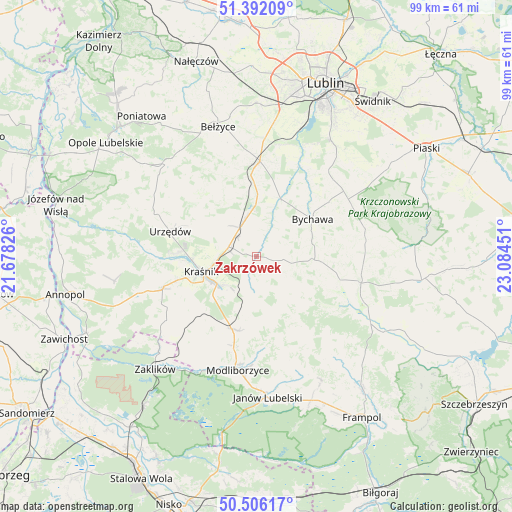
Zakrzówek GPS coordinates[2]
50° 57' 4.464" North, 22° 22' 52.968" East
| Map corner | latitude | longitude |
|---|---|---|
| Upper-left | 51.39209°, | 21.67826° |
| Center: | 50.95124°, | 22.38138° |
| Lower-right: | 50.50617°, | 23.08451° |
| Map W x H: | 98.5×98.5 km | = 61.2×61.2mi |
| max Lat: | 54.83135° ⇑56.4% North |
| Zakrzówek: | 50.95124° |
| min Lat: | ⇓43.6% South 49.21328° |
| min Long | Zakrzówek | max Long |
| 14.20249° | 22.38138° | 24.03723° |
| W 89.9%⇐ | ⇒10.1% E |
Elevation
Elevation of Zakrzówek is 214 m = 702 ft, and this is 22.6 m = 74 ft above average elevation for this country.
| Max E: |
974 m = 3196 ft | 35.2% |
| Zakrzówek | 214 m 702 ft | |
| Avg. | 191.4 m = 628 ft | |
Min E: |
-3 m = -10 ft | 64.8% |
See also: Poland elevation on elevation.city.
Geographical zone
Zakrzówek is located in North temperate zone (between Tropic of Cancer and the Arctic Circle). Distance of this North polar circle is 1735.9 km =1078.6 mi to North.| Distance of | km | miles | from Zakrzówek |
|---|---|---|---|
| North Pole | 4341.8 | 2697.9 | to North |
| Arctic Circle | 1735.9 | 1078.6 | to North |
| Tropic Cancer | 3059.3 | 1901 | to South |
| Equator | 5665.2 | 3520.2 | to South |


Nearby cities:
15 places around Zakrzówek: (largest is in red/bold)
• Batorz
13.7 km =8.5 mi,  145°
145°
• Borzechów
17.1 km =10.6 mi,  336°
336°
• Bychawa
12.8 km =8 mi,  55°
55°
• Bystrzyca
4.6 km =2.9 mi,  23°
23°
• Kraśnik
11.2 km =7 mi,  254°
254°
• Niedrzwica Duża
18.2 km =11.3 mi,  1°
1°
• Rudnik Pierwszy
4.2 km =2.6 mi,  74°
74°
• Rzeczyca Ziemiańska
18.3 km =11.4 mi,  229°
229°
• Strzyżowice
11.5 km =7.1 mi, 20°
• Sułów
5.2 km =3.2 mi,  196°
196°
• Szastarka
11.5 km =7.1 mi, 202°
• Urzędów
17.4 km =10.8 mi,  285°
285°
• Wilkołaz
7.4 km =4.6 mi, 342°
• Wysokie
20.4 km =12.7 mi,  102°
102°
• Zakrzew
16.2 km =10.1 mi,  114°
114°
Sources, notices
• [Note1] Compared only with cities in Poland existing in our database
• [Src1] Map data: © OpenStreetMap contributors (CC-BY-SA)
• [Src2] Other city data from geonames.org with taken over terms of usage.
• [Src3] Geographical zone / Annual Mean Temperature by Robert A. Rohde @ Wikipedia
