Bystrzyca geodata
Bystrzyca (Lublin) is a populated place; located in Poland in Europe/Warsaw (GMT+2) time zone. With population of 920 people, there are 2637 cities with bigger population in this country. Compared to other cities in Poland, 55.5% of cities are located further ↑North; 90.2% of cities are located further ←West and 65.3% of cities have lower elevation than Bystrzyca. Note1


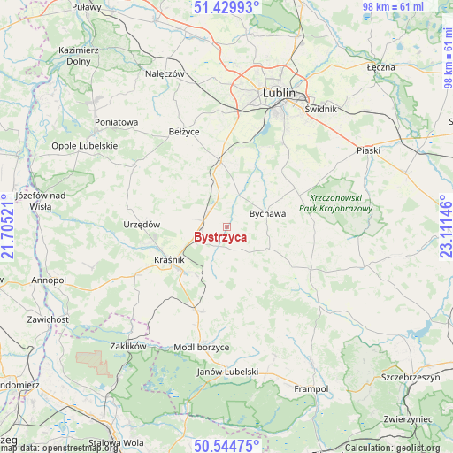
Bystrzyca GPS coordinates[2]
50° 59' 22.02" North, 22° 24' 29.988" East
| Map corner | latitude | longitude |
|---|---|---|
| Upper-left | 51.42993°, | 21.70521° |
| Center: | 50.98945°, | 22.40833° |
| Lower-right: | 50.54475°, | 23.11146° |
| Map W x H: | 98.4×98.4 km | = 61.1×61.1mi |
| max Lat: | 54.83135° ⇑55.5% North |
| Bystrzyca: | 50.98945° |
| min Lat: | ⇓44.5% South 49.21328° |
| min Long | Bystrzyca | max Long |
| 14.20249° | 22.40833° | 24.03723° |
| W 90.2%⇐ | ⇒9.8% E |
Elevation
Elevation of Bystrzyca is 215 m = 705 ft, and this is 23.6 m = 77 ft above average elevation for this country.
| Max E: |
974 m = 3196 ft | 34.7% |
| Bystrzyca | 215 m 705 ft | |
| Avg. | 191.4 m = 628 ft | |
Min E: |
-3 m = -10 ft | 65.3% |
See also: Poland elevation on elevation.city.
Geographical zone
Bystrzyca is located in North temperate zone (between Tropic of Cancer and the Arctic Circle). Distance of this North polar circle is 1731.7 km =1076 mi to North.| Distance of | km | miles | from Bystrzyca |
|---|---|---|---|
| North Pole | 4337.6 | 2695.3 | to North |
| Arctic Circle | 1731.7 | 1076 | to North |
| Tropic Cancer | 3063.6 | 1903.6 | to South |
| Equator | 5669.5 | 3522.9 | to South |


Nearby cities:
15 places around Bystrzyca: (largest is in red/bold)
• Batorz
16.6 km =10.3 mi,  158°
158°
• Borzechów
14.4 km =8.9 mi,  322°
322°
• Bychawa
9.2 km =5.7 mi,  71°
71°
• Jabłonna
17 km =10.6 mi,  49°
49°
• Kraśnik
14.7 km =9.1 mi,  240°
240°
• Niedrzwica Duża
14 km =8.7 mi,  354°
354°
• Rudnik Pierwszy
3.8 km =2.4 mi,  144°
144°
• Strzyżowice
6.9 km =4.3 mi,  18°
18°
• Sułów
9.8 km =6.1 mi,  199°
199°
• Szastarka
16.2 km =10.1 mi, 202°
• Urzędów
18.6 km =11.6 mi,  271°
271°
• Wilkołaz
4.9 km =3 mi,  304°
304°
• Zakrzew
16.9 km =10.5 mi,  130°
130°
• Zakrzówek
4.6 km =2.9 mi, 203°
• Żabia Wola
16.3 km =10.1 mi,  27°
27°
Sources, notices
• [Note1] Compared only with cities in Poland existing in our database
• [Src1] Map data: © OpenStreetMap contributors (CC-BY-SA)
• [Src2] Other city data from geonames.org with taken over terms of usage.
• [Src3] Geographical zone / Annual Mean Temperature by Robert A. Rohde @ Wikipedia
