Kornatka geodata
Kornatka (Lesser Poland) is a populated place; located in Poland in Europe/Warsaw (GMT+2) time zone. With population of 860 people, there are 2749 cities with bigger population in this country. Compared to other cities in Poland, 89.9% of cities are located further ↑North; 59.7% of cities are located further ←West and 90.2% of cities have lower elevation than Kornatka. Note1


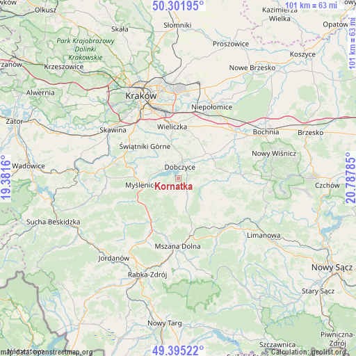
Kornatka GPS coordinates[2]
49° 51' 2.556" North, 20° 5' 4.992" East
| Map corner | latitude | longitude |
|---|---|---|
| Upper-left | 50.30195°, | 19.3816° |
| Center: | 49.85071°, | 20.08472° |
| Lower-right: | 49.39522°, | 20.78785° |
| Map W x H: | 100.8×100.8 km | = 62.6×62.6mi |
| max Lat: | 54.83135° ⇑89.9% North |
| Kornatka: | 49.85071° |
| min Lat: | ⇓10.1% South 49.21328° |
| min Long | Kornatka | max Long |
| 14.20249° | 20.08472° | 24.03723° |
| W 59.7%⇐ | ⇒40.3% E |
Elevation
Elevation of Kornatka is 330 m = 1083 ft, and this is 138.6 m = 455 ft above average elevation for this country.
| Max E: |
974 m = 3196 ft | 9.8% |
| Kornatka | 330 m 1083 ft | |
| Avg. | 191.4 m = 628 ft | |
Min E: |
-3 m = -10 ft | 90.2% |
See also: Poland elevation on elevation.city.
Geographical zone
Kornatka is located in North temperate zone (between Tropic of Cancer and the Arctic Circle). Distance of this North polar circle is 1858.3 km =1154.7 mi to North.| Distance of | km | miles | from Kornatka |
|---|---|---|---|
| North Pole | 4464.2 | 2773.9 | to North |
| Arctic Circle | 1858.3 | 1154.7 | to North |
| Tropic Cancer | 2937 | 1825 | to South |
| Equator | 5542.9 | 3444.2 | to South |


Nearby cities:
15 places around Kornatka: (largest is in red/bold)
• Borzęta
7.7 km =4.8 mi,  279°
279°
• Brzezowa
2.2 km =1.4 mi,  288°
288°
• Brzączowice
4.3 km =2.7 mi,  308°
308°
• Dobczyce
3.4 km =2.1 mi,  5°
5°
• Gdów
10.4 km =6.5 mi,  51°
51°
• Lipnik
6.9 km =4.3 mi,  180°
180°
• Osieczany
7.4 km =4.6 mi,  262°
262°
• Polanka
10.5 km =6.5 mi, 276°
• Poręba
7.7 km =4.8 mi,  218°
218°
• Raciechowice
4.2 km =2.6 mi,  99°
99°
• Trzemeśnia
5.2 km =3.2 mi,  240°
240°
• Wiśniowa
7.3 km =4.5 mi,  162°
162°
• Zasań
4.2 km =2.6 mi, 217°
• Zręczyce
10.4 km =6.5 mi,  67°
67°
• Łęki
5.2 km =3.2 mi,  250°
250°
Sources, notices
• [Note1] Compared only with cities in Poland existing in our database
• [Src1] Map data: © OpenStreetMap contributors (CC-BY-SA)
• [Src2] Other city data from geonames.org with taken over terms of usage.
• [Src3] Geographical zone / Annual Mean Temperature by Robert A. Rohde @ Wikipedia
