Brzączowice geodata
Brzączowice (Lesser Poland) is a populated place; located in Poland in Europe/Warsaw (GMT+2) time zone. With population of 1,230 people, there are 2146 cities with bigger population in this country. Compared to other cities in Poland, 88.7% of cities are located further ↑North; 59% of cities are located further ←West and 88.2% of cities have lower elevation than Brzączowice. Note1


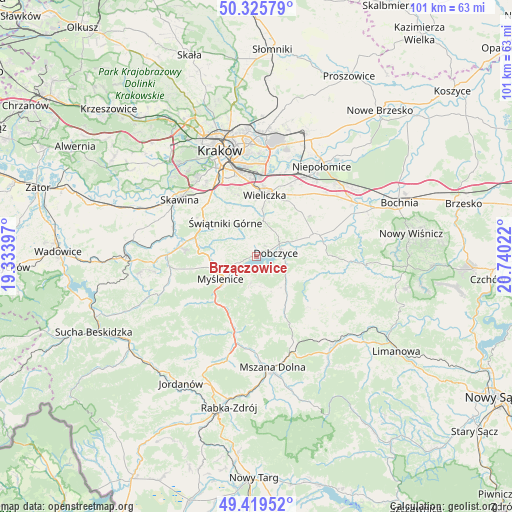
Brzączowice GPS coordinates[2]
49° 52' 29.208" North, 20° 2' 13.524" East
| Map corner | latitude | longitude |
|---|---|---|
| Upper-left | 50.32579°, | 19.33397° |
| Center: | 49.87478°, | 20.03709° |
| Lower-right: | 49.41952°, | 20.74022° |
| Map W x H: | 100.8×100.8 km | = 62.6×62.6mi |
| max Lat: | 54.83135° ⇑88.7% North |
| Brzączowice: | 49.87478° |
| min Lat: | ⇓11.3% South 49.21328° |
| min Long | Brzączowice | max Long |
| 14.20249° | 20.03709° | 24.03723° |
| W 59%⇐ | ⇒41% E |
Elevation
Elevation of Brzączowice is 310 m = 1017 ft, and this is 118.6 m = 389 ft above average elevation for this country.
| Max E: |
974 m = 3196 ft | 11.8% |
| Brzączowice | 310 m 1017 ft | |
| Avg. | 191.4 m = 628 ft | |
Min E: |
-3 m = -10 ft | 88.2% |
See also: Poland elevation on elevation.city.
Geographical zone
Brzączowice is located in North temperate zone (between Tropic of Cancer and the Arctic Circle). Distance of this North polar circle is 1855.6 km =1153 mi to North.| Distance of | km | miles | from Brzączowice |
|---|---|---|---|
| North Pole | 4461.5 | 2772.2 | to North |
| Arctic Circle | 1855.6 | 1153 | to North |
| Tropic Cancer | 2939.6 | 1826.6 | to South |
| Equator | 5545.6 | 3445.9 | to South |


Nearby cities:
15 places around Brzączowice: (largest is in red/bold)
• Borzęta
4.4 km =2.7 mi,  251°
251°
• Brzezowa
2.4 km =1.5 mi,  145°
145°
• Dobczyce
3.8 km =2.4 mi,  79°
79°
• Kornatka
4.3 km =2.7 mi,  128°
128°
• Krzyszkowice
8.2 km =5.1 mi,  276°
276°
• Myślenice
8.4 km =5.2 mi,  237°
237°
• Osieczany
5.3 km =3.3 mi,  227°
227°
• Pawlikowice
8.8 km =5.5 mi,  8°
8°
• Polanka
7.2 km =4.5 mi,  258°
258°
• Poręba
8.8 km =5.5 mi,  189°
189°
• Raciechowice
8.3 km =5.2 mi,  113°
113°
• Siepraw
7.1 km =4.4 mi,  308°
308°
• Trzemeśnia
5.4 km =3.4 mi, 191°
• Zasań
6.1 km =3.8 mi,  172°
172°
• Łęki
4.6 km =2.9 mi,  198°
198°
Sources, notices
• [Note1] Compared only with cities in Poland existing in our database
• [Src1] Map data: © OpenStreetMap contributors (CC-BY-SA)
• [Src2] Other city data from geonames.org with taken over terms of usage.
• [Src3] Geographical zone / Annual Mean Temperature by Robert A. Rohde @ Wikipedia
