Wiśniowa geodata
Wiśniowa (Lesser Poland) is a populated place; located in Poland in Europe/Warsaw (GMT+2) time zone. With population of 1,900 people, there are 1552 cities with bigger population in this country. Compared to other cities in Poland, 92.2% of cities are located further ↑North; 60.3% of cities are located further ←West and 92.1% of cities have lower elevation than Wiśniowa. Note1


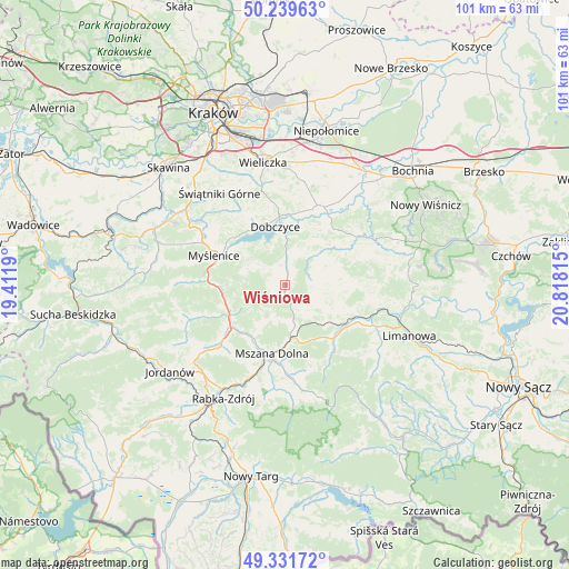
Wiśniowa GPS coordinates[2]
49° 47' 16.08" North, 20° 6' 54.072" East
| Map corner | latitude | longitude |
|---|---|---|
| Upper-left | 50.23963°, | 19.4119° |
| Center: | 49.7878°, | 20.11502° |
| Lower-right: | 49.33172°, | 20.81815° |
| Map W x H: | 101×100.9 km | = 62.8×62.7mi |
| max Lat: | 54.83135° ⇑92.2% North |
| Wiśniowa: | 49.7878° |
| min Lat: | ⇓7.8% South 49.21328° |
| min Long | Wiśniowa | max Long |
| 14.20249° | 20.11502° | 24.03723° |
| W 60.3%⇐ | ⇒39.7% E |
Elevation
Elevation of Wiśniowa is 358 m = 1175 ft, and this is 166.6 m = 547 ft above average elevation for this country.
| Max E: |
974 m = 3196 ft | 7.9% |
| Wiśniowa | 358 m 1175 ft | |
| Avg. | 191.4 m = 628 ft | |
Min E: |
-3 m = -10 ft | 92.1% |
See also: Poland elevation on elevation.city.
Geographical zone
Wiśniowa is located in North temperate zone (between Tropic of Cancer and the Arctic Circle). Distance of this North polar circle is 1865.3 km =1159 mi to North.| Distance of | km | miles | from Wiśniowa |
|---|---|---|---|
| North Pole | 4471.2 | 2778.3 | to North |
| Arctic Circle | 1865.3 | 1159 | to North |
| Tropic Cancer | 2930 | 1820.6 | to South |
| Equator | 5535.9 | 3439.8 | to South |


Nearby cities:
15 places around Wiśniowa: (largest is in red/bold)
• Brzezowa
8.8 km =5.5 mi,  331°
331°
• Dobczyce
10.5 km =6.5 mi,  349°
349°
• Jodłownik
8.8 km =5.5 mi,  99°
99°
• Kasina Wielka
6.6 km =4.1 mi,  167°
167°
• Kornatka
7.3 km =4.5 mi,  342°
342°
• Krasne-Lasocice
8.7 km =5.4 mi,  71°
71°
• Lipnik
2.2 km =1.4 mi,  273°
273°
• Pcim
11.1 km =6.9 mi,  248°
248°
• Poręba
7.1 km =4.4 mi,  277°
277°
• Raciechowice
6.6 km =4.1 mi,  17°
17°
• Skrzydlna
6.4 km =4 mi,  126°
126°
• Trzemeśnia
8 km =5 mi,  303°
303°
• Węglówka
6.3 km =3.9 mi,  199°
199°
• Zasań
6 km =3.7 mi,  307°
307°
• Łęki
8.8 km =5.5 mi, 306°
Sources, notices
• [Note1] Compared only with cities in Poland existing in our database
• [Src1] Map data: © OpenStreetMap contributors (CC-BY-SA)
• [Src2] Other city data from geonames.org with taken over terms of usage.
• [Src3] Geographical zone / Annual Mean Temperature by Robert A. Rohde @ Wikipedia
