Borzęta geodata
Borzęta (Lesser Poland) is a populated place; located in Poland in Europe/Warsaw (GMT+2) time zone. With population of 1,269 people, there are 2112 cities with bigger population in this country. Compared to other cities in Poland, 89.3% of cities are located further ↑North; 58% of cities are located further ←West and 93.3% of cities have lower elevation than Borzęta. Note1


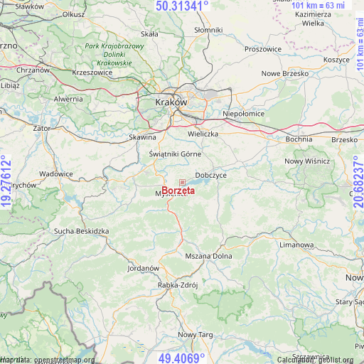
Borzęta GPS coordinates[2]
49° 51' 44.208" North, 19° 58' 45.264" East
| Map corner | latitude | longitude |
|---|---|---|
| Upper-left | 50.31341°, | 19.27612° |
| Center: | 49.86228°, | 19.97924° |
| Lower-right: | 49.4069°, | 20.68237° |
| Map W x H: | 100.8×100.8 km | = 62.6×62.6mi |
| max Lat: | 54.83135° ⇑89.3% North |
| Borzęta: | 49.86228° |
| min Lat: | ⇓10.7% South 49.21328° |
| min Long | Borzęta | max Long |
| 14.20249° | 19.97924° | 24.03723° |
| W 58%⇐ | ⇒42% E |
Elevation
Elevation of Borzęta is 377 m = 1237 ft, and this is 185.6 m = 609 ft above average elevation for this country.
| Max E: |
974 m = 3196 ft | 6.7% |
| Borzęta | 377 m 1237 ft | |
| Avg. | 191.4 m = 628 ft | |
Min E: |
-3 m = -10 ft | 93.3% |
See also: Poland elevation on elevation.city.
Geographical zone
Borzęta is located in North temperate zone (between Tropic of Cancer and the Arctic Circle). Distance of this North polar circle is 1857 km =1153.9 mi to North.| Distance of | km | miles | from Borzęta |
|---|---|---|---|
| North Pole | 4462.9 | 2773.1 | to North |
| Arctic Circle | 1857 | 1153.9 | to North |
| Tropic Cancer | 2938.2 | 1825.7 | to South |
| Equator | 5544.2 | 3445 | to South |


Nearby cities:
15 places around Borzęta: (largest is in red/bold)
• Brzezowa
5.6 km =3.5 mi,  96°
96°
• Brzączowice
4.4 km =2.7 mi,  71°
71°
• Bęczarka
8.2 km =5.1 mi,  282°
282°
• Dobczyce
8.2 km =5.1 mi,  75°
75°
• Jawornik
6.2 km =3.9 mi,  263°
263°
• Kornatka
7.7 km =4.8 mi, 99°
• Krzyszkowice
4.7 km =2.9 mi,  300°
300°
• Myślenice
4.3 km =2.7 mi,  222°
222°
• Osieczany
2.2 km =1.4 mi,  174°
174°
• Polanka
2.9 km =1.8 mi,  268°
268°
• Poręba
7.8 km =4.8 mi,  159°
159°
• Siepraw
6 km =3.7 mi,  345°
345°
• Trzemeśnia
4.9 km =3 mi,  141°
141°
• Zasań
6.8 km =4.2 mi,  132°
132°
• Łęki
4 km =2.5 mi, 138°
Sources, notices
• [Note1] Compared only with cities in Poland existing in our database
• [Src1] Map data: © OpenStreetMap contributors (CC-BY-SA)
• [Src2] Other city data from geonames.org with taken over terms of usage.
• [Src3] Geographical zone / Annual Mean Temperature by Robert A. Rohde @ Wikipedia
