Klembów geodata
Klembów (Mazovia) is a seat of a third-order administrative division; located in Poland in Europe/Warsaw (GMT+2) time zone. With population of 920 people, there are 2637 cities with bigger population in this country. Compared to other cities in Poland, 74.8% of cities are located further ↓South; 77.3% of cities are located further ←West and 83.2% of cities have higher elevation than Klembów. Note1


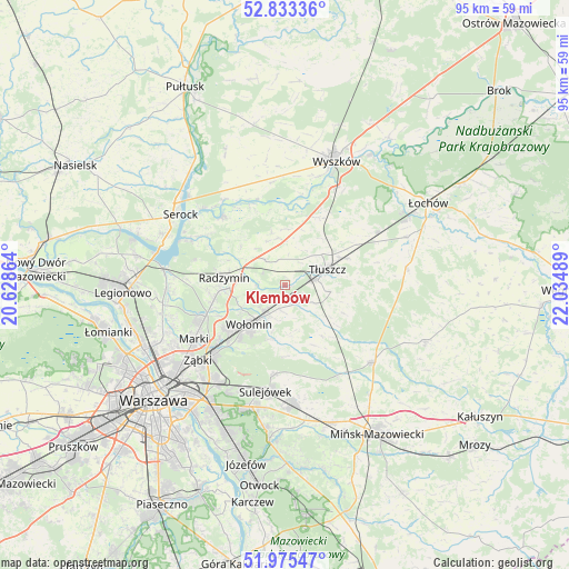
Klembów GPS coordinates[2]
52° 24' 23.4" North, 21° 19' 54.336" East
| Map corner | latitude | longitude |
|---|---|---|
| Upper-left | 52.83336°, | 20.62864° |
| Center: | 52.4065°, | 21.33176° |
| Lower-right: | 51.97547°, | 22.03489° |
| Map W x H: | 95.4×95.4 km | = 59.3×59.3mi |
| max Lat: | 54.83135° ⇑25.2% North |
| Klembów: | 52.4065° |
| min Lat: | ⇓74.8% South 49.21328° |
| min Long | Klembów | max Long |
| 14.20249° | 21.33176° | 24.03723° |
| W 77.3%⇐ | ⇒22.7% E |
Elevation
Elevation of Klembów is 93 m = 305 ft, and this is 98.4 m = 323 ft below average elevation for this country.
| Max E: |
974 m = 3196 ft | 83.2% |
| Avg. | 191.4 m = 628 ft | |
| Klembów | 93 m = 305 ft | |
Min E: |
-3 m = -10 ft | 16.8% |
See also: Poland elevation on elevation.city.
Geographical zone
Klembów is located in North temperate zone (between Tropic of Cancer and the Arctic Circle). Distance of this North polar circle is 1574.1 km =978.1 mi to North.| Distance of | km | miles | from Klembów |
|---|---|---|---|
| North Pole | 4180 | 2597.3 | to North |
| Arctic Circle | 1574.1 | 978.1 | to North |
| Tropic Cancer | 3221.1 | 2001.5 | to South |
| Equator | 5827.1 | 3620.8 | to South |


Nearby cities:
15 places around Klembów: (largest is in red/bold)
• Czarna
8.3 km =5.2 mi,  239°
239°
• Duczki
5.6 km =3.5 mi,  209°
209°
• Dąbrówka
8.9 km =5.5 mi,  345°
345°
• Jasienica
5.5 km =3.4 mi,  81°
81°
• Kobyłka
11.9 km =7.4 mi,  231°
231°
• Nowe Lipiny
6.8 km =4.2 mi,  217°
217°
• Ostrówek
3.1 km =1.9 mi,  128°
128°
• Poświętne
10.5 km =6.5 mi,  144°
144°
• Radzymin
10.1 km =6.3 mi,  275°
275°
• Stare Grabie
4.2 km =2.6 mi,  192°
192°
• Słupno
12.2 km =7.6 mi,  258°
258°
• Tłuszcz
7.5 km =4.7 mi,  69°
69°
• Wołomin
9.6 km =6 mi, 219°
• Zabrodzie
13 km =8.1 mi,  26°
26°
• Zielonka
16.3 km =10.1 mi, 225°
Sources, notices
• [Note1] Compared only with cities in Poland existing in our database
• [Src1] Map data: © OpenStreetMap contributors (CC-BY-SA)
• [Src2] Other city data from geonames.org with taken over terms of usage.
• [Src3] Geographical zone / Annual Mean Temperature by Robert A. Rohde @ Wikipedia
