Poświętne geodata
Poświętne (Mazovia) is a seat of a third-order administrative division; located in Poland in Europe/Warsaw (GMT+2) time zone. With population of 290 people, there are 3624 cities with bigger population in this country. Compared to other cities in Poland, 73.2% of cities are located further ↓South; 78.3% of cities are located further ←West and 74.5% of cities have higher elevation than Poświętne. Note1


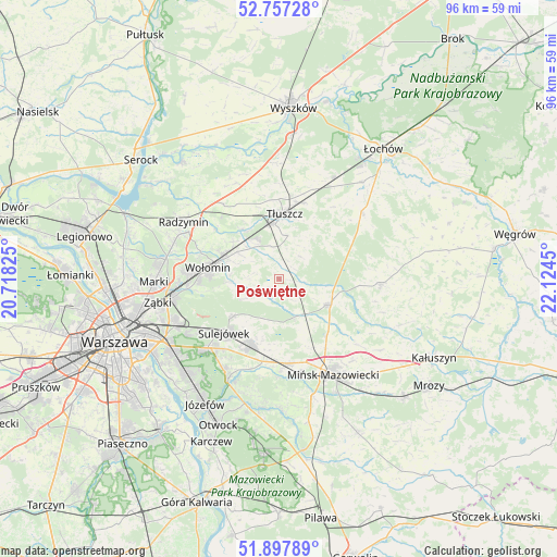
Poświętne GPS coordinates[2]
52° 19' 46.812" North, 21° 25' 16.932" East
| Map corner | latitude | longitude |
|---|---|---|
| Upper-left | 52.75728°, | 20.71825° |
| Center: | 52.32967°, | 21.42137° |
| Lower-right: | 51.89789°, | 22.1245° |
| Map W x H: | 95.6×95.6 km | = 59.4×59.4mi |
| max Lat: | 54.83135° ⇑26.8% North |
| Poświętne: | 52.32967° |
| min Lat: | ⇓73.2% South 49.21328° |
| min Long | Poświętne | max Long |
| 14.20249° | 21.42137° | 24.03723° |
| W 78.3%⇐ | ⇒21.7% E |
Elevation
Elevation of Poświętne is 112 m = 367 ft, and this is 79.4 m = 260 ft below average elevation for this country.
| Max E: |
974 m = 3196 ft | 74.5% |
| Avg. | 191.4 m = 628 ft | |
| Poświętne | 112 m = 367 ft | |
Min E: |
-3 m = -10 ft | 25.5% |
See also: Poland elevation on elevation.city.
Geographical zone
Poświętne is located in North temperate zone (between Tropic of Cancer and the Arctic Circle). Distance of this North polar circle is 1582.7 km =983.4 mi to North.| Distance of | km | miles | from Poświętne |
|---|---|---|---|
| North Pole | 4188.5 | 2602.6 | to North |
| Arctic Circle | 1582.7 | 983.4 | to North |
| Tropic Cancer | 3212.6 | 1996.2 | to South |
| Equator | 5818.5 | 3615.4 | to South |


Nearby cities:
15 places around Poświętne: (largest is in red/bold)
• Czarna
13.9 km =8.6 mi,  287°
287°
• Duczki
9.6 km =6 mi, 292°
• Dębe Wielkie
14.5 km =9 mi,  174°
174°
• Halinów
12.1 km =7.5 mi,  201°
201°
• Jasienica
9.4 km =5.8 mi,  355°
355°
• Klembów
10.5 km =6.5 mi,  324°
324°
• Kobyłka
15.4 km =9.6 mi,  274°
274°
• Nowe Lipiny
10.7 km =6.6 mi, 287°
• Ostrówek
7.6 km =4.7 mi,  331°
331°
• Stanisławów
9.7 km =6 mi,  117°
117°
• Stare Grabie
8.3 km =5.2 mi,  302°
302°
• Sulejówek
13.5 km =8.4 mi,  230°
230°
• Tłuszcz
11.3 km =7 mi,  4°
4°
• Wesoła
15.8 km =9.8 mi,  238°
238°
• Wołomin
12.2 km =7.6 mi,  275°
275°
Sources, notices
• [Note1] Compared only with cities in Poland existing in our database
• [Src1] Map data: © OpenStreetMap contributors (CC-BY-SA)
• [Src2] Other city data from geonames.org with taken over terms of usage.
• [Src3] Geographical zone / Annual Mean Temperature by Robert A. Rohde @ Wikipedia
