Czarna geodata
Czarna (Mazovia) is a populated place; located in Poland in Europe/Warsaw (GMT+2) time zone. With population of 700 people, there are 3061 cities with bigger population in this country. Compared to other cities in Poland, 74.1% of cities are located further ↓South; 76.1% of cities are located further ←West and 82.2% of cities have higher elevation than Czarna. Note1


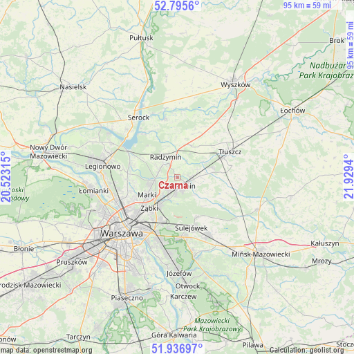
Czarna GPS coordinates[2]
52° 22' 6.132" North, 21° 13' 34.572" East
| Map corner | latitude | longitude |
|---|---|---|
| Upper-left | 52.7956°, | 20.52315° |
| Center: | 52.36837°, | 21.22627° |
| Lower-right: | 51.93697°, | 21.9294° |
| Map W x H: | 95.5×95.5 km | = 59.3×59.3mi |
| max Lat: | 54.83135° ⇑25.9% North |
| Czarna: | 52.36837° |
| min Lat: | ⇓74.1% South 49.21328° |
| min Long | Czarna | max Long |
| 14.20249° | 21.22627° | 24.03723° |
| W 76.1%⇐ | ⇒23.9% E |
Elevation
Elevation of Czarna is 95 m = 312 ft, and this is 96.4 m = 316 ft below average elevation for this country.
| Max E: |
974 m = 3196 ft | 82.2% |
| Avg. | 191.4 m = 628 ft | |
| Czarna | 95 m = 312 ft | |
Min E: |
-3 m = -10 ft | 17.8% |
See also: Poland elevation on elevation.city.
Geographical zone
Czarna is located in North temperate zone (between Tropic of Cancer and the Arctic Circle). Distance of this North polar circle is 1578.4 km =980.8 mi to North.| Distance of | km | miles | from Czarna |
|---|---|---|---|
| North Pole | 4184.2 | 2599.9 | to North |
| Arctic Circle | 1578.4 | 980.8 | to North |
| Tropic Cancer | 3216.9 | 1998.9 | to South |
| Equator | 5822.8 | 3618.1 | to South |


Nearby cities:
15 places around Czarna: (largest is in red/bold)
• Duczki
4.4 km =2.7 mi,  98°
98°
• Klembów
8.3 km =5.2 mi,  59°
59°
• Kobyłka
3.8 km =2.4 mi,  212°
212°
• Marki
9.8 km =6.1 mi,  237°
237°
• Nowe Lipiny
3.3 km =2.1 mi,  110°
110°
• Ostrówek
9.9 km =6.2 mi,  76°
76°
• Radzymin
6 km =3.7 mi,  331°
331°
• Rembertów
12.7 km =7.9 mi,  199°
199°
• Stanisławów Pierwszy
11.9 km =7.4 mi,  273°
273°
• Stare Grabie
6.3 km =3.9 mi,  88°
88°
• Słupno
5.1 km =3.2 mi,  290°
290°
• Wesoła
12.7 km =7.9 mi,  180°
180°
• Wołomin
3.3 km =2.1 mi,  161°
161°
• Zielonka
8.5 km =5.3 mi, 212°
• Ząbki
11.8 km =7.3 mi,  224°
224°
Sources, notices
• [Note1] Compared only with cities in Poland existing in our database
• [Src1] Map data: © OpenStreetMap contributors (CC-BY-SA)
• [Src2] Other city data from geonames.org with taken over terms of usage.
• [Src3] Geographical zone / Annual Mean Temperature by Robert A. Rohde @ Wikipedia
