Dąbrówka geodata
Dąbrówka (Mazovia) is a seat of a third-order administrative division; located in Poland in Europe/Warsaw (GMT+2) time zone. With population of 535 people, there are 3448 cities with bigger population in this country. Compared to other cities in Poland, 76.2% of cities are located further ↓South; 77% of cities are located further ←West and 85.2% of cities have higher elevation than Dąbrówka. Note1


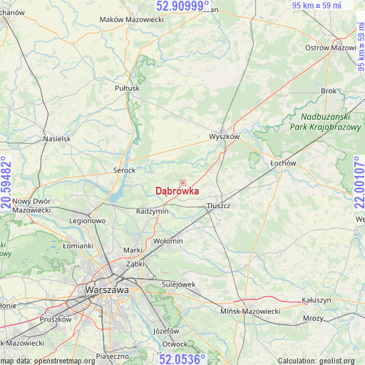
Dąbrówka GPS coordinates[2]
52° 29' 1.968" North, 21° 17' 52.584" East
| Map corner | latitude | longitude |
|---|---|---|
| Upper-left | 52.90999°, | 20.59482° |
| Center: | 52.48388°, | 21.29794° |
| Lower-right: | 52.0536°, | 22.00107° |
| Map W x H: | 95.2×95.2 km | = 59.2×59.2mi |
| max Lat: | 54.83135° ⇑23.8% North |
| Dąbrówka: | 52.48388° |
| min Lat: | ⇓76.2% South 49.21328° |
| min Long | Dąbrówka | max Long |
| 14.20249° | 21.29794° | 24.03723° |
| W 77%⇐ | ⇒23% E |
Elevation
Elevation of Dąbrówka is 89 m = 292 ft, and this is 102.4 m = 336 ft below average elevation for this country.
| Max E: |
974 m = 3196 ft | 85.2% |
| Avg. | 191.4 m = 628 ft | |
| Dąbrówka | 89 m = 292 ft | |
Min E: |
-3 m = -10 ft | 14.8% |
See also: Poland elevation on elevation.city.
Geographical zone
Dąbrówka is located in North temperate zone (between Tropic of Cancer and the Arctic Circle). Distance of this North polar circle is 1565.5 km =972.8 mi to North.| Distance of | km | miles | from Dąbrówka |
|---|---|---|---|
| North Pole | 4171.4 | 2592 | to North |
| Arctic Circle | 1565.5 | 972.8 | to North |
| Tropic Cancer | 3229.7 | 2006.8 | to South |
| Equator | 5835.7 | 3626.1 | to South |


Nearby cities:
15 places around Dąbrówka: (largest is in red/bold)
• Czarna
13.7 km =8.5 mi,  200°
200°
• Duczki
13.5 km =8.4 mi,  182°
182°
• Jasienica
10.9 km =6.8 mi,  135°
135°
• Klembów
8.9 km =5.5 mi,  165°
165°
• Nowe Lipiny
14.1 km =8.8 mi,  187°
187°
• Ostrówek
11.5 km =7.1 mi,  155°
155°
• Radzymin
10.8 km =6.7 mi,  225°
225°
• Rybno
12 km =7.5 mi,  38°
38°
• Serock
15.8 km =9.8 mi,  280°
280°
• Somianka
8.6 km =5.3 mi,  357°
357°
• Stare Grabie
12.8 km =8 mi, 173°
• Słupno
14.7 km =9.1 mi,  220°
220°
• Tłuszcz
11.1 km =6.9 mi,  122°
122°
• Zabrodzie
8.7 km =5.4 mi,  70°
70°
• Zatory
15 km =9.3 mi,  328°
328°
Sources, notices
• [Note1] Compared only with cities in Poland existing in our database
• [Src1] Map data: © OpenStreetMap contributors (CC-BY-SA)
• [Src2] Other city data from geonames.org with taken over terms of usage.
• [Src3] Geographical zone / Annual Mean Temperature by Robert A. Rohde @ Wikipedia
